by | Apr 5, 2010
Currockbilly Mountain in the southern part of Morton National Park may be described in a single word: scrub. It can also be described in two words: thick scrub. In three words you’d probably say thick wet scrub. If you want it in more than 3 words (a lot more), well, it goes something like this.
by | Mar 29, 2010
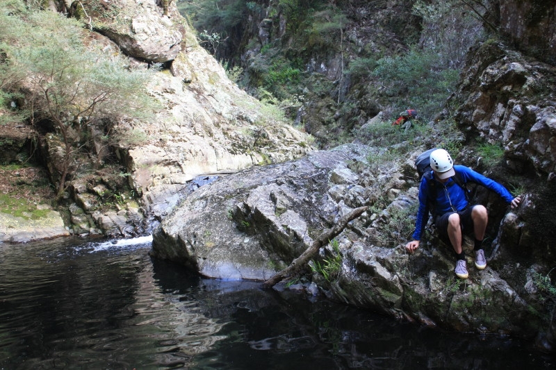
The combination of short notice, Monday canyoning and wet weather meant I ended up doing the trip on my own, which was fine. It gave me a chance to have a nice sleep in, do some shopping and catch up with a friend as well. As for the canyon, all up it took just over 2 hours, taking the longer route via Edinburgh Castle Rock and having plenty of pauses for photos. A great little trip which while short is very scenic, and the abseil down the waterfall was lovely. The rain made everything look prettier, and ensured I had the whole place to myself. Definitely a good pic for a quick run through on a relaxing day off. The only downside is I think my Volleys have finally worn out completely, but they’ve had a good run.
by | Mar 28, 2010
Thankfully Gaping Gill is the shortest canyon in the Claustral system, so despite our lazy start time of 9am, which was blown out of the water when T1’s Nokia which mistakenly set his clock back for daylight saving, making him an hour late, it was a great day. The late start was fitting given the trips organisation had been haphazard at best, with T1 and I lending out gear to Kat and Nicole, and forcing Seb to spend several hours frantically calling everyone he could find from Suboir on Saturday in an attempt to get his hands on a harness.
by | Mar 21, 2010
T1 and I made an early escape from the city on the Friday afternoon, getting to my place by about 5 so we could pack the car and head off. The drive up the mountains was wonderful, the weather forecast good, and we were at the start of King Pin Fire Trail by about 8.30, a good hour ahead of the second car load. We set up the tent, scavenged a healthy pile of fire wood and lit of great little fire. The wine soon came out, and by the time Jiri, Cat and Bjorn arrived we were more than a little merry.About midnight it was off to bed, with the alarm set for six.
by | Mar 14, 2010
In the usual manner of such trips we met bright and early at the roundabout outside Strathfield station on Saturday morning. The drive to Deep Pass takes about 3 hours from Sydney taking into account, of course, a stop at the North Richmond Bakery to stock up on pies, pastries and caffeinated beverages. The weather looked promising at this point although the temperature remained somewhat on the cooler end of the spectrum.
by | Mar 14, 2010
For me, at least, the Coast Walk is developing a bit of a reputation as a “safe fallback” when there’s no time to organise private transport to more exotic locations, or when the four hours of train ride for a trip to Katoomba is too daunting. Regardless I have enjoyed the walk every time, in all manner of bizarre weather conditions and (on a couple of occasions) pitch darkness and/or weeping inebriation. Allegedly.
by | Feb 27, 2010
After meeting at Circular Quay we travelled by ferry to Athol Wharf, below Taronga Zoo, and set out on the Harbourside walk on the first leg to Clifton Gardens. Past Bradley’s Head the track is through bushland which is still largely unchanged bespite 222 years of European settlement. We noticed a few artists along the walk sketching or painting views of the Harbour a la Tom Roberts.
by | Feb 21, 2010
By miraculous good fortune and coincidental timing no one got permanently lost in the labyrinth of forest trails that sprout northwards from the Zig Zag railway. It was Friday evening, dark, some had arrived early, others late, but somehow it was a single cohesive convoy of vehicles that eventually rolled into our pleasant open camp site after rendezvousing at various points along the way.
by | Jan 23, 2010
After travelling up by various means and at various times the group coalesced on Saturday morning over an obligatory cup of tea. Then it was off to Mt Thurat and into the gorge fairly high up, entering in the lower part of Thurat Creek. This gave us the opportunity to see some of the upper gorge which was beautiful on this hot day, with several wades, short swims and downclimbs.
by | Dec 31, 2009
Alfred and I made our way out to Kanangra walls late on New Years Eve, armed with plenty of food and booze, and the grand plan to do Kanangra Main followed by a two day effort in Davies. From the lookout we managed to spot a smattering of tiny fireworks exploding more than 100 kilometres away, before making our way down to Dance Floor cave where some wine was drunk, tales told and the new year ushered in. The next…