Date: 24+25/9/2022
Trip leader: Terry Sze
Party: Akash, Badour, Enzo, Jackson, Jeffrey, Nao, Socheat, Tran Uyen Nhi, Yu Ching
Here’s the long-promised trip report. As photos don’t work on WordPress I’ve put a version with all the photos on my own website instead: https://www.err404notfound.xyz/hiking/warrumbungle-national-park
It has been some sort of tradition to do camping trips during mid-semester breaks of uni, as this is when others usually have more free time. This national park came up to me on the Discover NSW National Parks guide, the little leaflet they hand to tourists in tourist information centres (I got mine in Broken Hill). While few might actually pay attention to the descriptions, the presence of Australia’s first dark sky park caught my attention. My only stargazing experience recently was pulling off Jenolan Caves Roa, staring over the milky way and the dense clusters of stars. This was when the idea of doing a stargazing-bushwalking trip came along. This park turns out to be a good choice, being in relatively close proximity to Sydney but still reasonably far away. When I planned this trip it was repeatedly mentioned as “Dubbo Camping Trip” as Dubbo is the closest major town recognisable by most people, including non-bushwalkers.
The bushwalking component was planned way earlier and we spent 2-3 weeks organising the camping parts. The initial plan for transport was to rent a 12-seater van, but it turned out that the vans ran out of stock and we went for an 8-seater plus Socheat’s 5-seater car instead. Jeffrey and Socheat are the main drivers and Budour assisted in driving. We also did planning on the food. At first, it was planned to be fully catered with Budour helping with the food, but as space in the cars is a concern we simplified the plan with some deciding to have their own meals instead. In the end, only half the group had the catered meal. Some sharing of tents was also organised on the gear night and amongst the members, saving vehicle space. Most members of the trip met up on the gear night organised by Sunil and had some socialising before the actual trip.
With some quick packing the day before we’ve made a smooth start on Saturday morning. Both drivers met up at Westmead to pick up the rental car and the rest of the group. All members showed up on time at around 8 am, loading luggage on a side street behind the train station. The initial sections through the Blue Mtns and Great Western Hwy took longer than expected due to school holiday traffic and increased law enforcement. Going up Blaxland, then slowly through to Katoomba and Medlow Bath, is a brand new experience for some members where they experienced a different route and scenery. Initially, Budour was driving the leg up the Blue Mtns, but upon discussion with Socheat, it would be safer and quicker to let Jeffrey drive it, instead of someone new to Australian roads and holds an international driving license. A slow oil tanker down the slope from Mt Vic to Little Hartley caused some delays, and through that section, we saw someone trying to scooter down with a coles bag in his handle. Such a brave act, we thought, till he tripped over a pothole, fell over on the side of a busy road, and everyone in both cars laughed really hard at him.
We first stopped at Lithgow Hungry Jacks for food, then to Pearsons Lookout where there is a great view over Capertee Valley, Gardens of Stone NP and Pantoneys Crown. Capertee Valley is the world’s second-largest canyon, even larger than the Grand Canyon in the US. One member on this trip had been to the real Grand Canyon and refuses to acknowledge that what he saw is a canyon. This area is rather close to the previous Dry Canyon trip in Wollemi National Park and therefore gives similar views. The weather near Ben Bullen and Newnes wasn’t as good with occasional heavy rain, but fortunately, it did clear off shortly after Capertee. Rain droplets were so heavy that we thought it was hail (which it isn’t).
After a brief driver switch, we headed up towards Mudgee, and then onto Dunedoo. It has been a very scenic drive over vast Central West NSW terrain and scenery. Smooth slopes, grassy hilltops and cattle all crafted a perfect landscape for both the drivers and team members to enjoy. Despite more than half being asleep, many were amused by the regional landscape and spent time taking photos and videos. On our way, we passed through Lake Windamere near Cudgegong where the scenery did impress us. From what I heard from the other car Socheat wanted to do a stop by the lake, but Jeffrey, who is driving Socheat’s car, insisted that they should stop at Mudgee instead. While the road trip was scenic some members still prefer prioritising reaching the national park as soon as possible.
From Mudgee, we went on to Dunedoo and all the way to the Warrumbungles. The terrain flattens out as the great dividing range fades out towards Dubbo, and that is where we saw more farmlands and fields. It is spring season and canola fields sprung up on both sides of the highway, offering satisfying golden yellow colour that we haven’t ever seen before. We made a very brief stop at Dunedoo to visit the silo art, which did look good when it was seen in person. The highway also travels along abandoned train stations and railway infrastructure, giving a peek into how regional towns used to flourish.
Dunedoo was where our drivers got pulled over by highway patrol police, the very first time in the trips I’ve led so far. Budour took the lead driving at a speed of 80km/h out of the town, without realising that speed limits for most towns are 50km/h (or 60km/h in some places). A highway patrol car was awaiting long for speed violations, chased them and pulled them over the street. After some interaction, a speeding ticket was issued and the car was let go. People in Budour’s car and four of us in Socheat’s car behind saw it in surprise as we haven’t had this type of encounter before. Moments later the rental car kept going, along with Jeffrey and Budour’s smiley faces. Budour was really excited about receiving a speeding ticket – after all what’s a more solid proof of having been on Australian roads than a speeding ticket? Perhaps this is a really unique experience that international students could share with their parents back home.
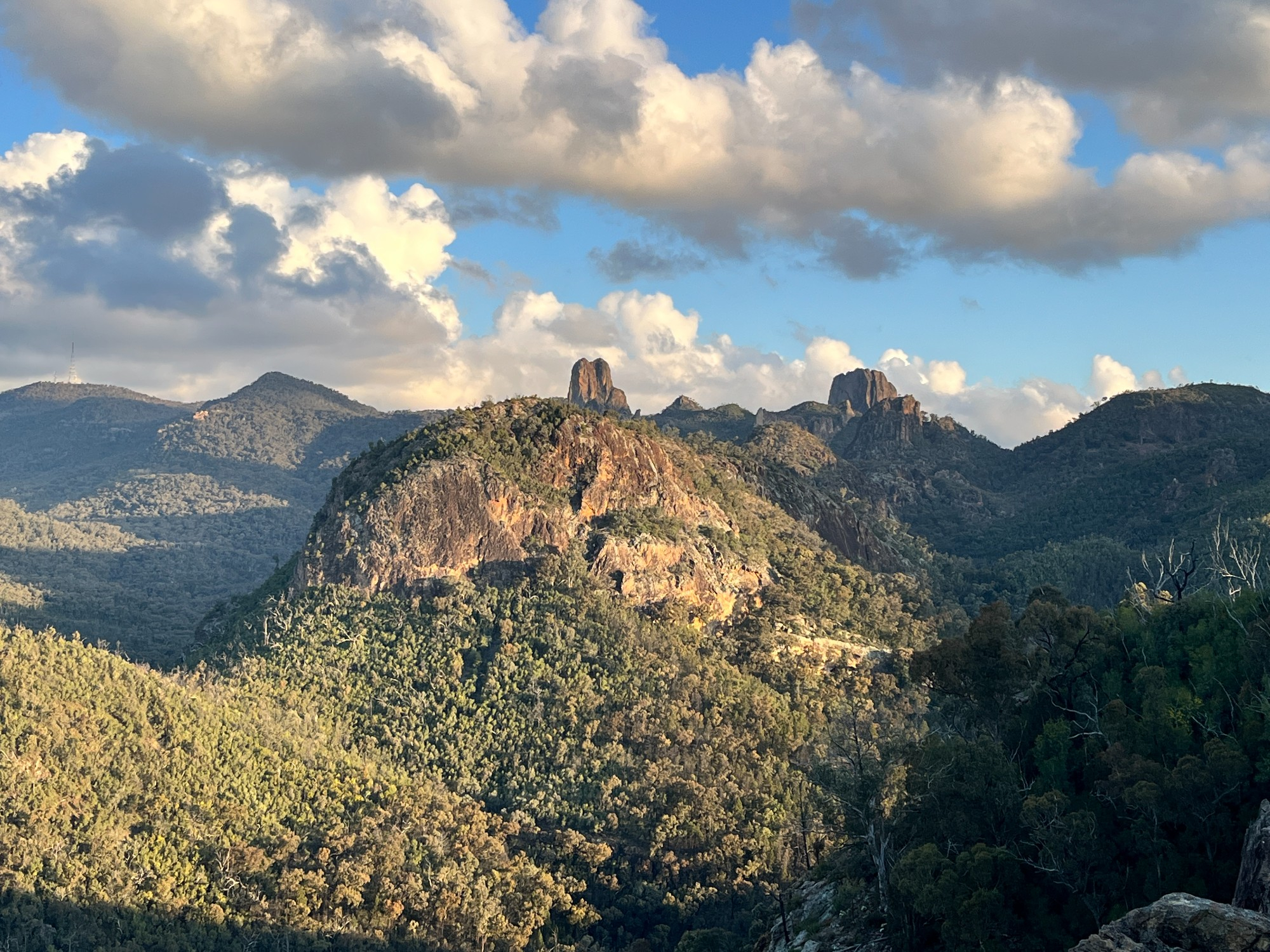
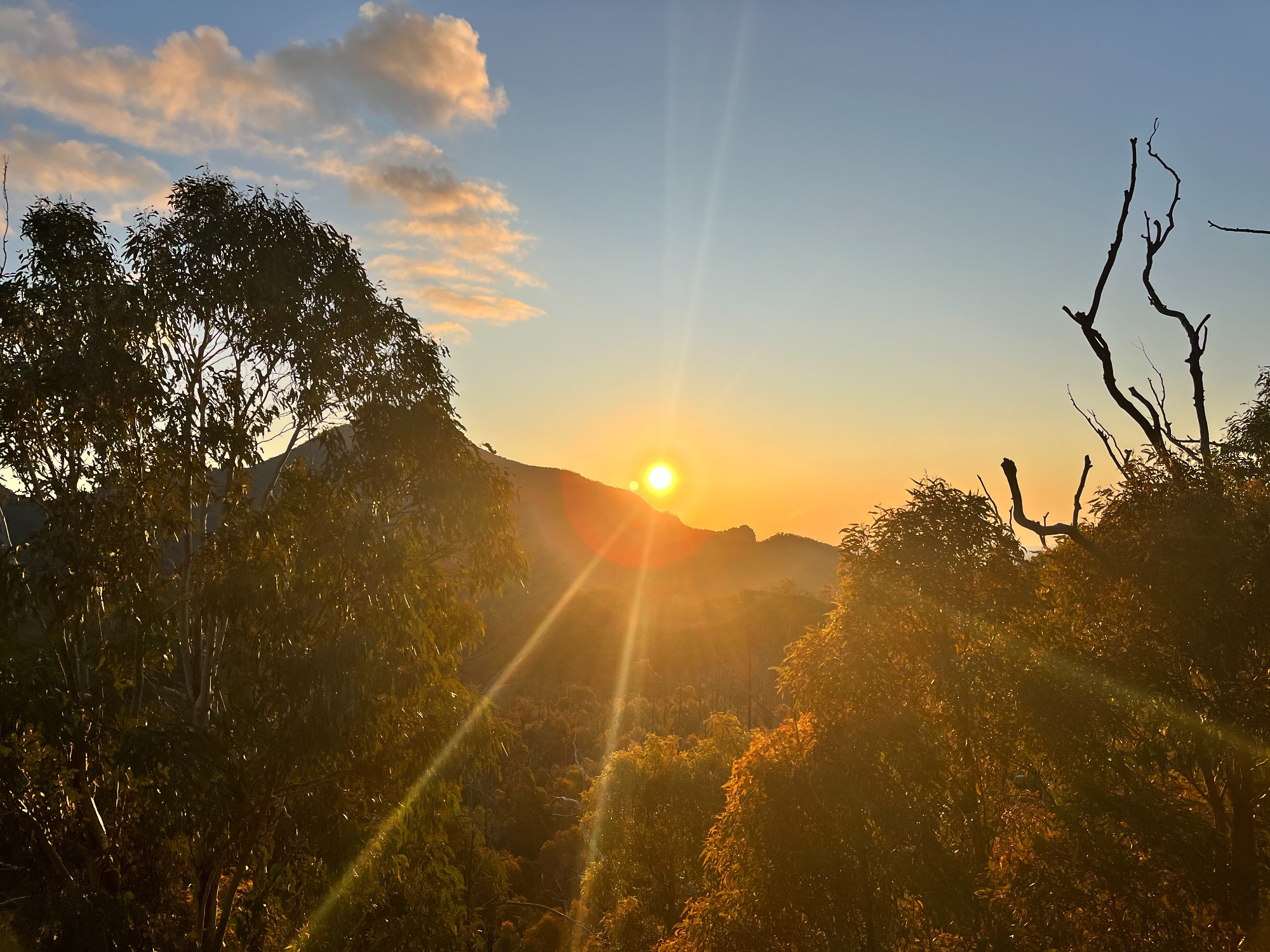
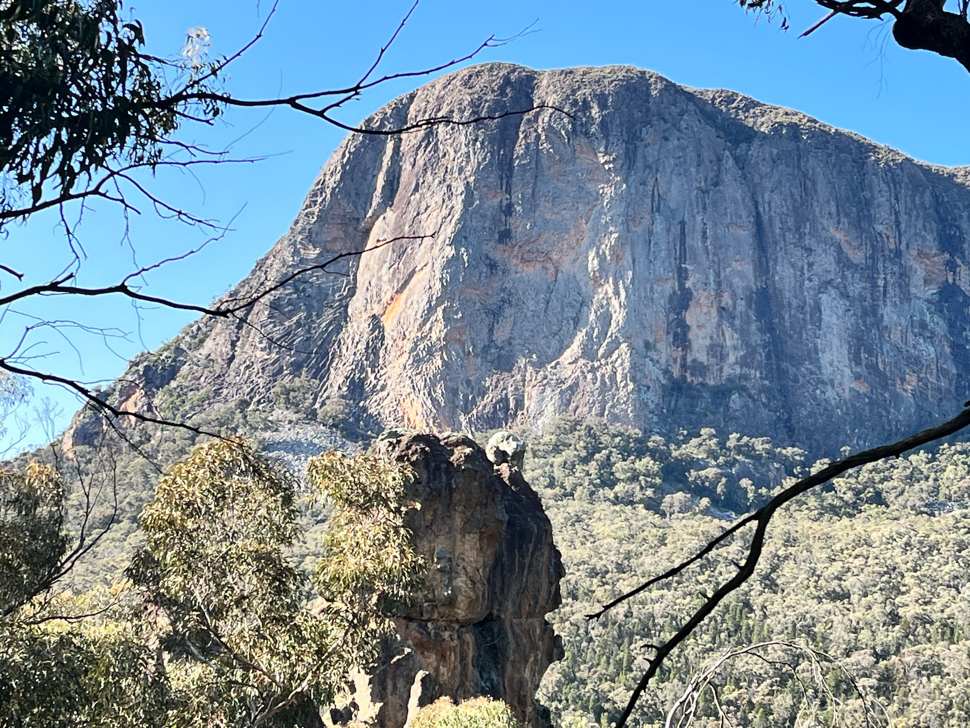
Our group arrived at the national park at around 4 pm, starting off with a hike to Fans Horizon for a view of the Breadknife and Grand High Tops. It is a short walk up 100m in elevation and ends at a lookout. As usual, I was in the front with Jeffrey, Jackson and Akash as we release our energy after being stuck in a car for 6 hours, while the girls and Socheat were at the back. It was right at sunset when we got up, where the orange shades match perfectly with the rocks over the hills. The front group decided to trek a bit forward along the trail after the lookout to the end of the trail, where it faced westwards with the view of Mt Exmouth.
Most of the Warrumbungles consist of volcanic rocks arranged randomly, vastly different from the sandstone jungle in the Sydney area. The word Warrumbungle is considered to mean “crooked mountains”, which clearly reflects the landscape we saw. For me, it wasn’t as impressive as I first imagined, but for many, it was more than enough for an Instagram-able shot. Perhaps I still prefer glasshouse mountains in Brisbane, where the rocks stand out of the sunshine coast plains instead of being hidden in mountain ranges.
On the way up to the lookout, we also saw some goats and kangaroos. Outside of Sydney, it is easy to encounter kangaroos or wallabies but it is often hard for conventional smartphone cameras to take good photos of them due to limitations on zooming in. Once we got back to the carpark, the sky dimmed slightly and stars started to show up. The sky was so clear that Scorpius is visible right after sunset when the sky was still bright. Most in the group had no problem spotting it as not many stars are visible under relatively bright conditions. Akash, the most knowledgeable person in our group in astronomy, helped point out the tail, and slowly up to the head, with the help of a slightly orange star down on the tail. This is a relatively easy constellation to see as even my friends in the UK can spot them from photos I send them, but they wouldn’t be able to see them in person as it would be below the horizon.
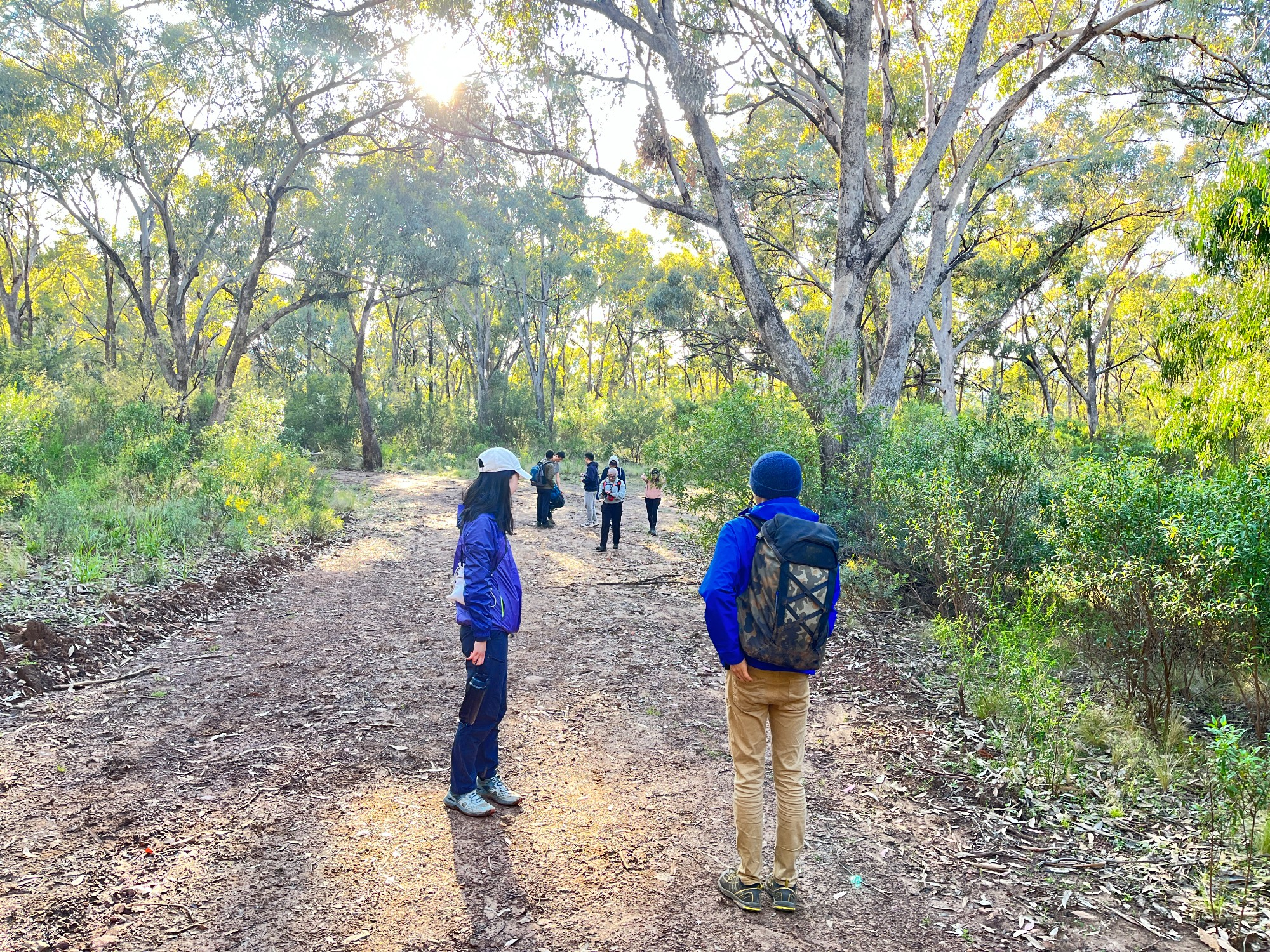
We did a short drive to the start of Burbie Canyon track, where the track heads off to our campsite – Burbie Camp. With our tents and multi-kg loads on our backs, we started the 3km walk to the campsite. Budour and I have the heaviest load, while others simply travelled lite with relatively small packs. Budour planned to sleep without the tent right underneath the stars and bought a very heavy mattress to stay warm, which Jeffrey had to carry for her. Budour and Jeffrey are the only two who slept without a tent and in a sleeping bag instead. The track comes with multiple creek crossings, adding difficulty to the walk. Crossing the creek while staying dry is easy during the day but hard at night, and each crossing involves us spending some time trekking up and down the creek to find a suitable spot. We counted a total of 6 creek crossings one way, which wasn’t an easy walk considering the weight behind us. 2-3 people in our group are first-time campers and it was fortunate that no one slipped into the water.
The same group of boys were in front as we went uphill, and Socheat stayed with the girls giving confidence to everyone on the trip. The final section involves a steep slope, which we didn’t feel the steepness at night and only realised during the daytime. As the walk progresses the distance between the front and the rear group grew and those in front were very far ahead, but I still managed to make sure everyone is on the way by counting the number of lamps (I count 9 and safely assume there are 10 people, which is the right number).
Burbie Camp is a relatively large campsite with unmarked space, and we simply camped around the fireplace. As we arrived we unloaded the tents, set them up very close to each other, and Jackson started working on the fireplace. Budour got the sausages out and started heating them up with a stove. It took some time to heat up sausages and while we are waiting, the fireplace was ready and we got in for some marshmallows. Socheat returned to his car to get the remaining food and left us shortly after.
The milky way was at its highest point by the time we got to the campsite and slowly sets into the bush as time passes by. Looking up into the sky we saw some of the largest clusters of stars we have ever seen, unique to this dark sky park. Akash had a good time pointing out constellations with the aid of his star walk app, as so many of them are visible to bare eyes. Such density of stars feels very unreal, making this an even better place to stargaze than the outback. Shortly after we also saw Jupiter, the bright round star with a shade of gas surrounding it. Saturn was also visible later in the night.
Jeffrey went on with photos of the milky way shortly after arriving at the campground, making good use of the time. Sunny and Jeffrey both got good cameras and spent some time exploring different modes. Most people tried long exposures on iPhones, which did give some good images but nowhere comparable to what is visible with bare eyes. Budour used the 30-second exposure on her iPhone 13 Pro and got some of the best photos possible with a mobile device. For conventional devices, an iPhone 13 with long exposure is good enough for photos of the milky way.
Nao went to bed shortly after setting up her tent. Hours later Socheat came back with some food, and those members of the group with organised meals went on having dinner. The weather started to get cold but it still felt good having warm meals on a picnic mat. We shared the campsite with another person who doesn’t seem to be happy with us staying up late. While effort has been made to minimise the volume he still doesn’t seem to be satisfied and shouts “go to sleep” near midnight. Popping up on a campsite at late night doesn’t seem to be common in national parks, perhaps it is something to be avoided in the future. At this time most went to bed with just 1-2 staying up late for chit-chats. Socheat forgot his sleeping bag in the car and headed off to the carpark again (this is his 4th trip on the track). He got lost at a T-intersection midway on the track, where he had to turn left but instead went straight ahead. After seeing an unusual uphill he returned to the campsite. As he was now warm after the exercise he slept straight away.
That brings us to Sunday, the 2nd day of the trip. Akash woke up early, walked up the track towards Mt Exmouth and scrambled up a nearby rock for sunrise photos. Others also woke up as the birds chimed in. When I woke up I saw Socheat casually coming up from the track, saying to us that he got lost on the track at midnight. We had some breakfast and headed off the campsite at 7 am for the bushwalk towards the breadknives.
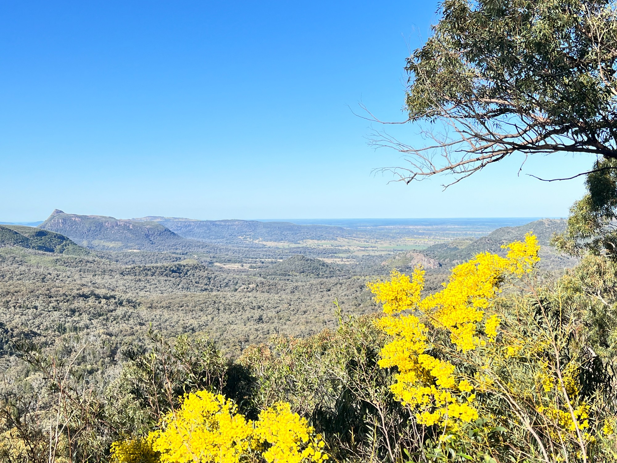
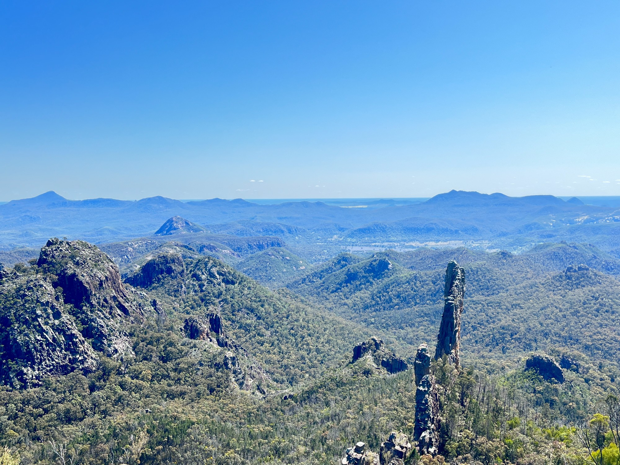
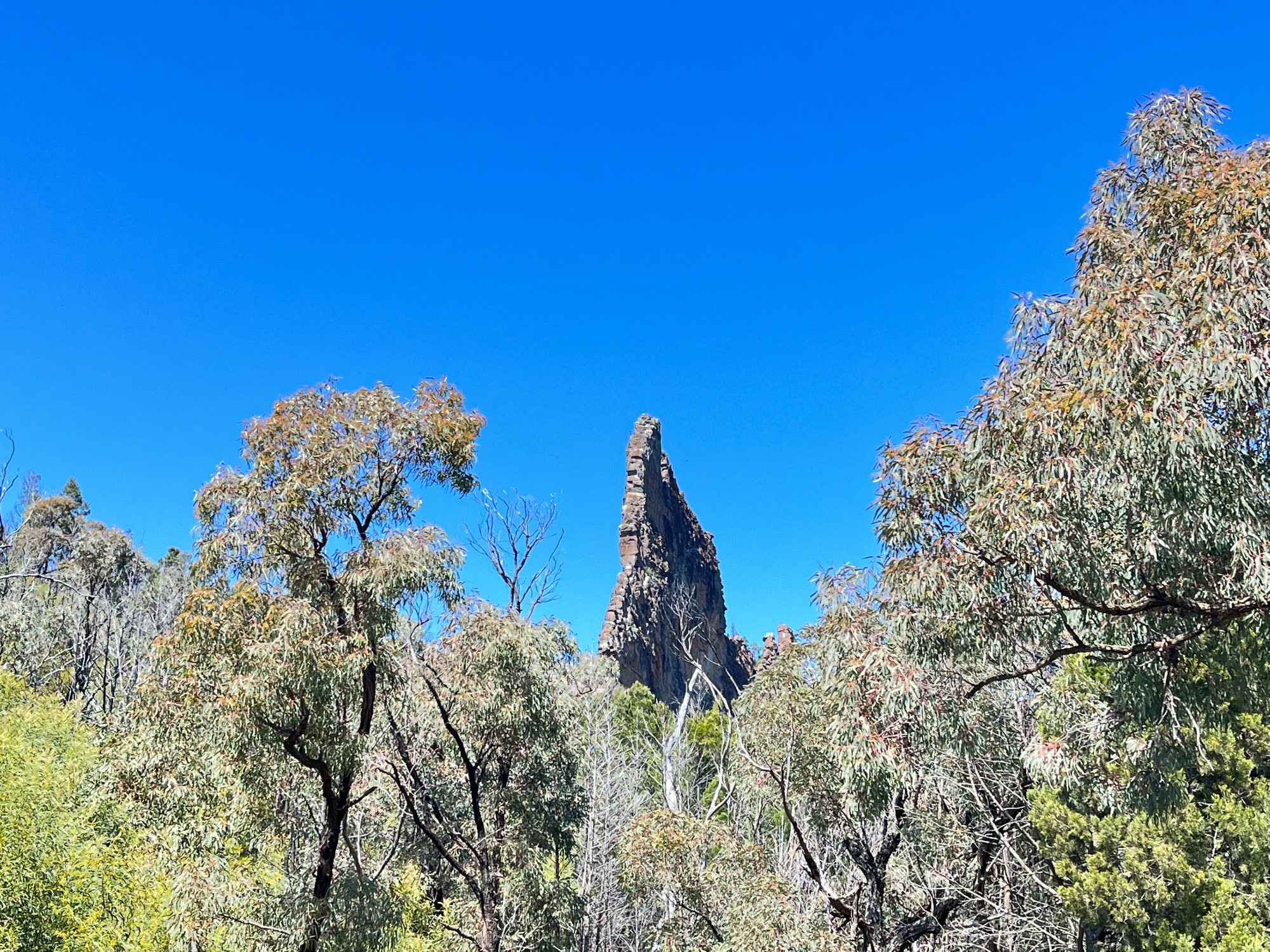
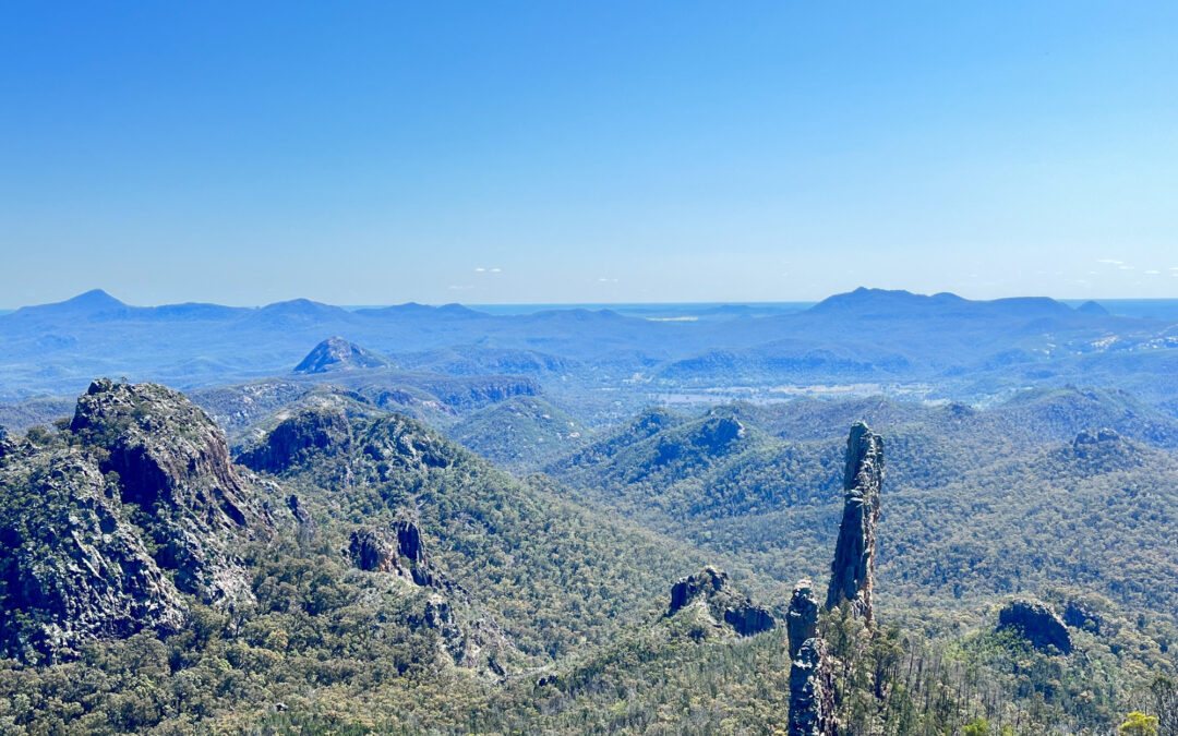
With just around 6 hours for this ~15km walk, we had no time to spare and started fast walking on the track. Outside of the campsite is a firetrail that leads up 100m in elevation to Danu Camp. Everyone went on the walk except Socheat, who chose to prioritise having energy in driving back home over going on the walk. At Danu Camp, Nhi and Nao decided to leave the group and head back to the campsite, perhaps as the exercise was too intensive for both. This leaves 7 left in the group who went on towards the more hilly parts of the track. The track passes through some eroded slopes where vegetation has been washed off and what remained was a stony wall, perhaps due to a landslide. Along the track, we saw some goats, faraway plains facing Dubbo and Moree, and the base of Bluff Mountain. We did a short scramble to get a better view of Bluff Mountain and the rocky cliffs that face us. Looking closer at the mountain show hexagonal columns spreading in a fan-like shape, perhaps indicating that rocks were formed by volcanic activity.
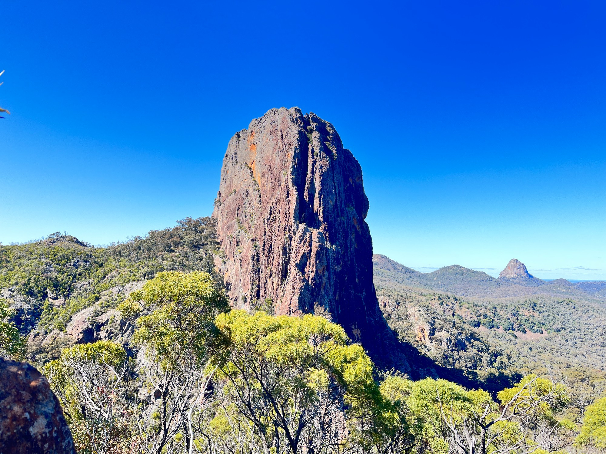
After passing through Dow’s camp at the base of Bluff Mountain, we were officially on Grand High Tops Circuit, and it didn’t take long for us to head onto Grand High Tops for a view of the breadknife. Most people scrambled up a nearby rock while Budour went along the hilltop for photos instead. This is probably the most unreal and scenic spot of this national park, where the breadknife stood up as just a thin slice of rock.
The nearby rock face that we scrambled up might seem scramble-able from the rear, but its difficulty shows up only the moment we put our hands on it. The rocks are slightly slanted with a smooth surface, proving that they might not be suitable for beginners. I reminded some not to do the scramble as it is beyond their ability, but even the least experienced members did the scramble (except Budour who went to another view spot). It was only the moment we went up that we realise it was right on the edge of a cliff. The way down did not appear as hard as it seemed, but those who are new to bushwalks still found it rather hard as the rock surface was slippery. Nearby is a large round-shaped rock that looked more like mountains in Minecraft (a video game).
The walking track was not difficult at all (except for all the elevation) as it was well paved and marked. We saw many other bushwalkers slowly making their way up the steep stairs, even small kids carrying their own loads. The track followed closely along the bottom of a cliff, then down to Barlow Hut where we continued on the loop track towards Dow’s Camp. Despite being in close proximity to the breadknife, much of its view is concealed in bush and could only be seen at one view spot outside Barlow Hut. There is a toilet near the hut, something we haven’t seen for days. Two days after this bushwalking trip I was in outback NSW and the couple we met also mentioned that they were here a couple of days ago. Perhaps this was where we met, except that I backtracked nearly 1000km down south and back north.
Two hours later after some fast trekking along the track, we made our way back to Burbie Camp right at 1 pm. It was incredible that all members of the group could keep up with the rapid pace along the hilly terrain, with a max walking speed of 6.7km/h and elevation gain of over 600 metres. After a quick lunch and packing up our tents, we met with the rest of the group and went down 3km towards the carpark. Socheat was already at the carpark and everyone else reached there at 3 pm. Everyone was exhausted after the hike, including the two girls who didn’t come along. It seemed that carrying all the loads is a bit too extreme for those new to overnight camping, but I believed that most people had a great time venturing along the bush.
We took fewer stops in the return drive, with just one at Mudgee McDonald’s. Having the sunset shade over the fields and cattle gives a different vibe from the drive to the park. After a stop at Mudgee for dinner, both vehicles headed straight to Westmead where everyone was dropped off, the rental vehicle was returned and most got back home by train.