Date: 29/1-7/2/2021
Trip leader: Paul Griffiths
Party: Frances, Geoff, Kirstie (guest)
Mud, Bad and Dangerous to Know [1] – The Western Arthurs Traverse
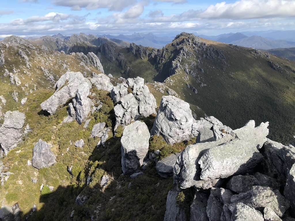
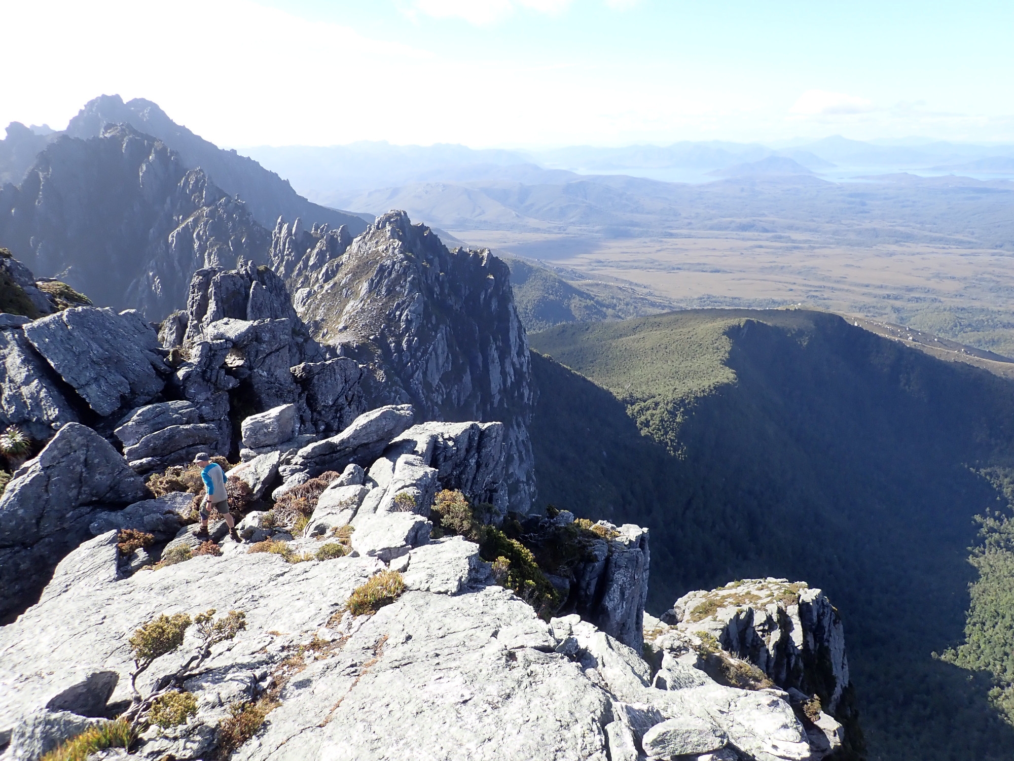
The Western Arthurs are an ice-carved range of mountains in southwest Tasmania. Its jagged peaks and spectacular glacial lakes feature in some of the most famous photographs of the Tasmanian wilderness. First traversed in the 1960s, the range is famous for wild and unpredictable weather. The track is much improved, and navigation will not trouble an experienced bushwalker with a copy of Chapman [2]. But the best training regime for the Western Arthurs remains a trip to a bouldering gym wearing a full pack and accompanied by a friend who can poke at you with a stick to imitate the effect of the scrub. Even that won’t provide the full experience, as no gym will let you hose down the bouldering wall with liquid mud.
Day Zero: The Escape from Quarantine
Although we started planning months ago, we threw this trip together hurriedly when the state border reopened! Quickly and apologetically rebooking leave from work, and in one case cutting short a multi-day canyoning trip, we met at the airport on Wednesday morning and flew to Hobart. Where Frances and Kirstie were told that because they had taken a train to the airport, not driven, they would need to do two weeks quarantine. After 24 hours of heroically battling the bureaucracy with the help of their local MP, they busted themselves from the quarantine hotel and we headed for the southwest. Wild Island Adventures, who drove us there, could only pick up on what would now be Day 6 or Day 9. Six days would leave no reserve days for bad weather, so we chose to make this a nine day trip and buried a box of extra food near the start of the track as we only had seven days food in our packs. This gave us an Indian meal, a nice bottle of red and a packet of Tim Tams to look forward to on our return.
Day One: On the Mud Track [3]
Our transport dropped us at Scotts Peak Dam – literally the end of the road and the start of the Port Davey track. Seeing the range come into view across Lake Pedder was a moment of great excitement. It was mid-afternoon and we had plenty of time to walk the four hours to the first camp at Junction Creek. For half an hour the track is well-constructed and we romped along boardwalks and over little bridges before beginning the mud-slogging for which the Port Davey track is renowned. Gaiters are essential to keep mud out of boots, rather than for protection against scrub, as later in the trip. Trekking poles are useful for distinguishing splash-through mud from deeper mud that will trap feet and suck off boots. The creeks, however, were trickles that we could walk through, rather than the knee-deep torrents we had to wade through last time, so we made good time. When we reached Junction Creek we walked happily over the logs that we had used to brace ourselves against the current on the previous trip.
There were two people going in and two pairs coming out at the campsite. As we set up tents by the creek, on sites that had been under water when we camped here last summer, they confirmed the stories we had heard about rat infestation. In the morning I paid the price for not listening – a rat had chewed right through my pack, through a drybag and into a sachet of oats – one breakfast down. Every group we met suffered from rat attacks and we adopted the practice of keeping all food inside the tent and away from the tent walls. Other groups were hanging their packs from trees.
Day 2. Up, Up and Away
Next morning was clear, with magnificent views of the range as we walked towards Alpha Moraine. Once on the moraine the mud was replaced by a track of crushed quartzite and we climbed happily towards the ridgeline 600m above. Towards the top, however, as we were working our way through the cliffline, a strong easterly wind came up, gusting to 55km. This was a bit challenging on narrow, exposed paths carrying a full pack. We were still in t-shirts and sunhats from the plains and very keen to change into the rainjackets and beanies we would wear for most of the trip, but there was nowhere practical to stop, so we pressed on, getting quite cold, until we emerged onto the moorland, where we dropped behind some rocks, piled warm clothes on and had lunch.
The traverse begins with a track of stone slabs, built to reduce erosion and protect the delicate alpine vegetation. There has been a lot of trackwork on the Arthurs, but we quickly realised that the primary intention is to protect the environment from the walkers, not the walkers from the environment. It’s the easy walking on open, relatively flat moorland and the swampy flats around the lakes that have received the attention.
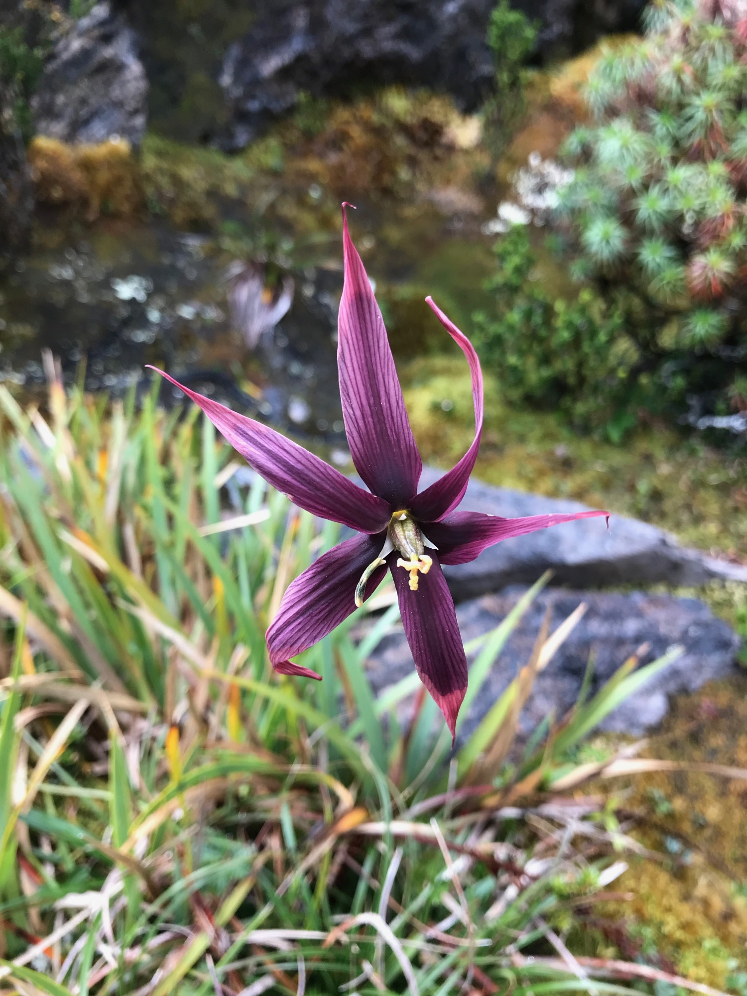
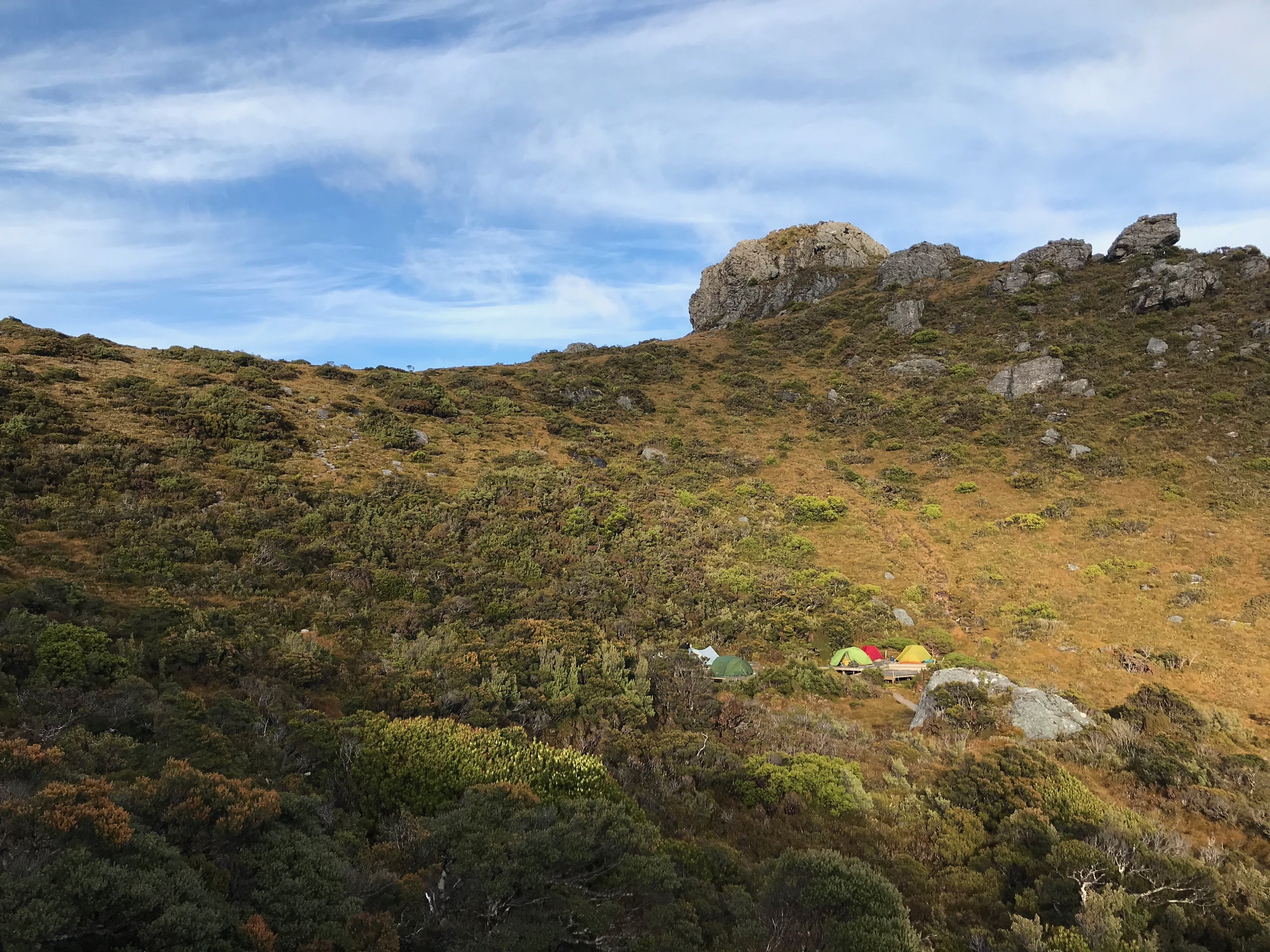
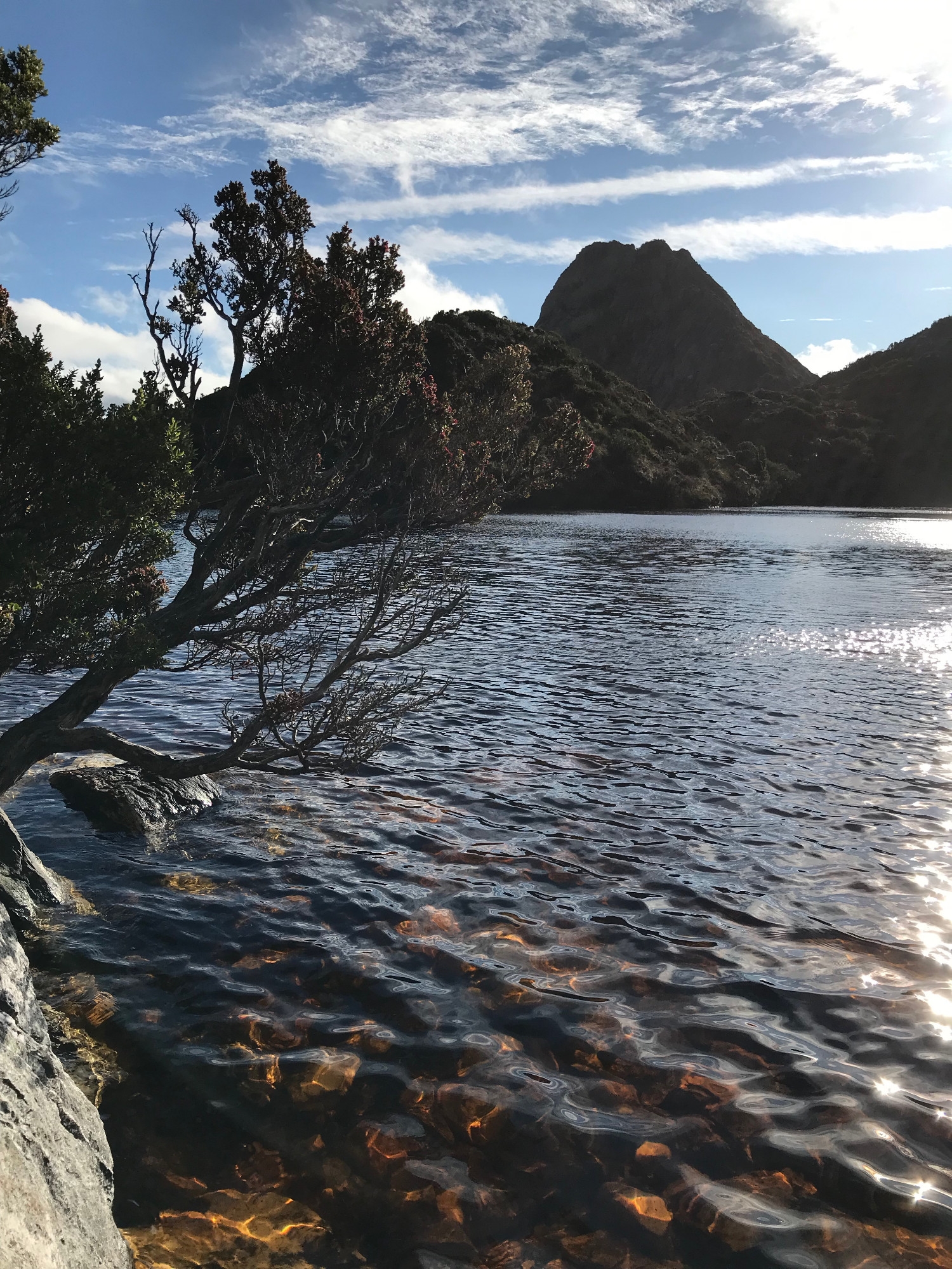
The track led steadily upwards, past Mt Hesperus and the Capella Crags, before reaching Lake Cygnus, our first campsite. Unlike later lakes, this does not require a precipitous descent of a couple of hundred meters to reach it, so we were in a relaxed frame of mind when we arrived and erected our tents on a small area of rubber matting cut into the shelter of some scrub. The coca-cola coloured water turned to gold at the edges of the lake over the white quartz sand, and the moorland round the lake was ablaze with wildflowers and the strikingly coloured foliage of heathland plants.
Day 3. For the Rain it Raineth Every Day [4]
In the morning the track climbed steadily upwards onto the slopes on Mt Hayes. The weather closed in and we were soon walking in light rain. Despite the lack of views, we dropped packs and made a one-hour detour to the summit, our first ‘Abel’ on this trip (a list of all the peaks in Tasmania over 1100m). We were unsure which of the final, rocky pinnacles was higher, so two of us climbed each and photographed our misty friends on the summit opposite.
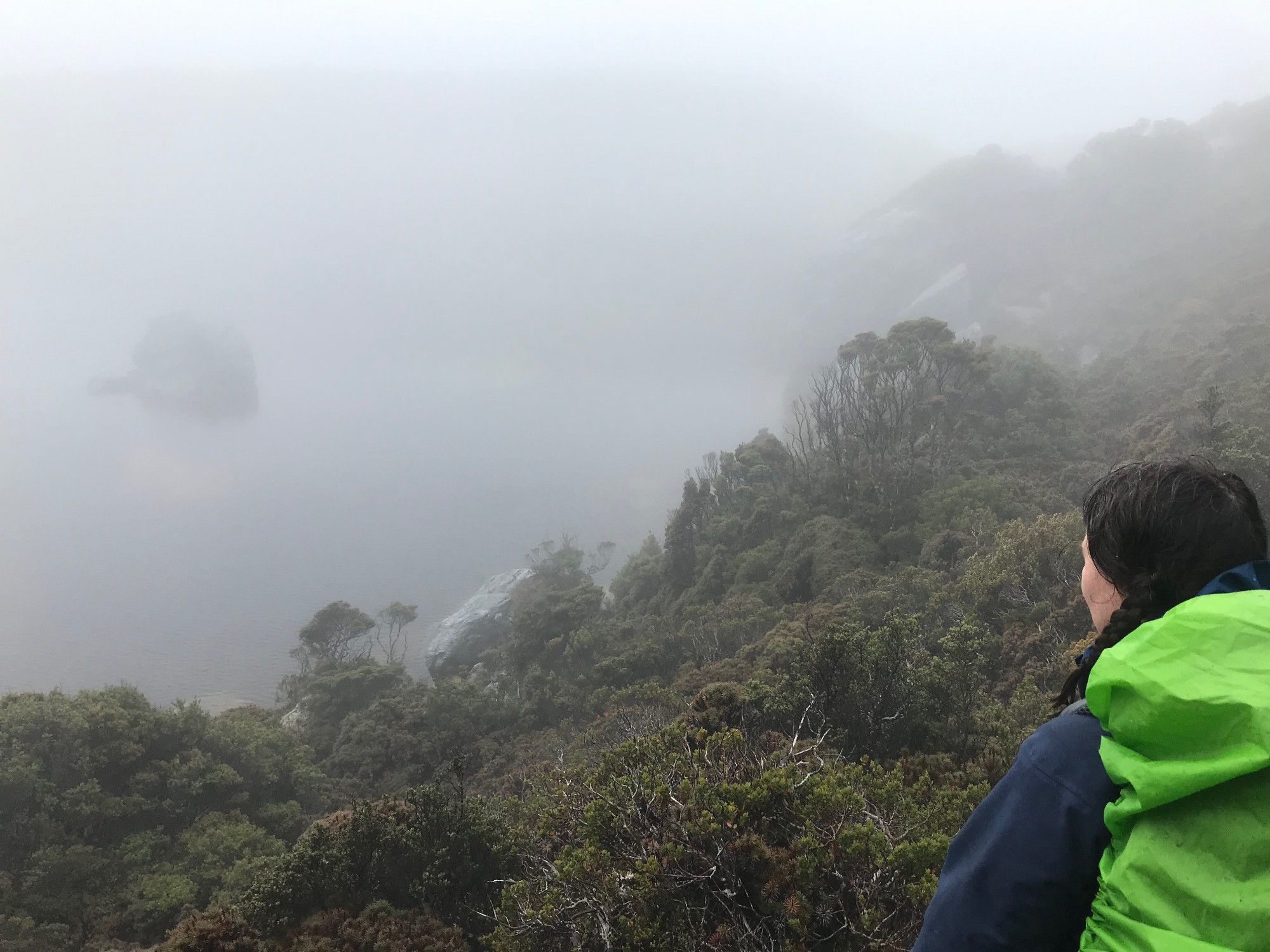
From here the track drops to Square Lake, which we were eager to see, but the fog was so dense that only crossing the outlet stream alerted us to the fact that we had arrived at the lake. Hoping for a view we climbed onto the moraine that dams the lake, but there was little to be seen, so we started to climb to the ridge above Lake Oberon. A party of three, who we later learnt were from Wollongong, passed us on the climb.
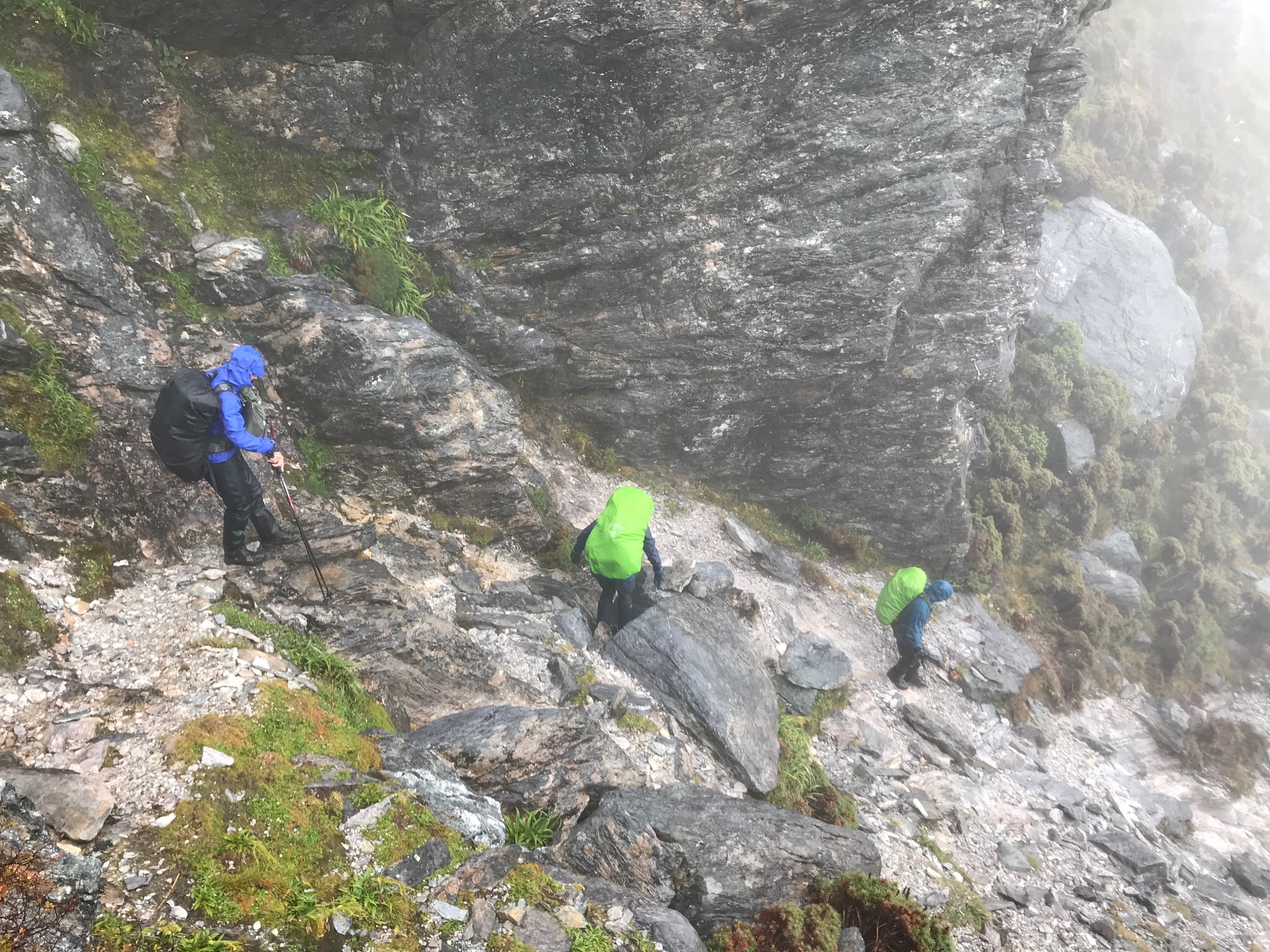
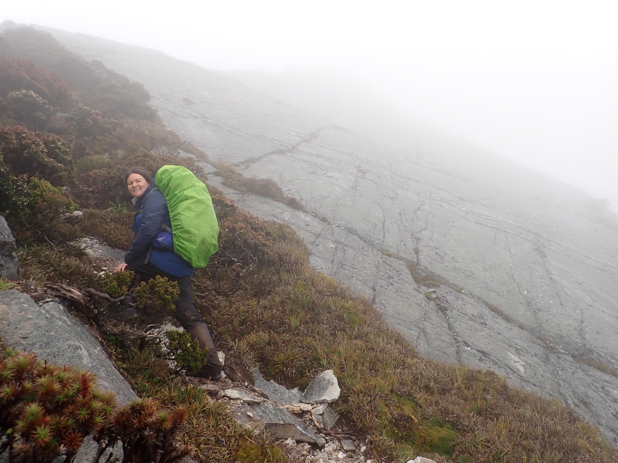
The steep but clear track of white quartz was running like a stream, water parting either side of our boots like a river flowing around the piers of a bridge. Even the best raingear won’t keep you dry after a few hours of consistent, driving rain. Its real value is windproofing, with the merino underneath providing insulation. We were all wearing a couple of layers of merino, three-layer gortex jackets, rainpants and gaiters. Nevertheless, the combination of wet clothes, rainwater running down us and wind was chilling and we needed to keep moving to stay warm. Lunch was replaced with a couple of high-energy snack breaks.
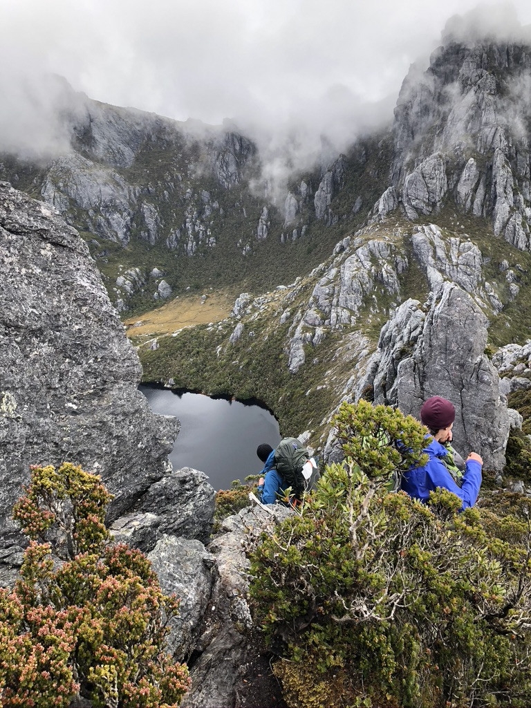
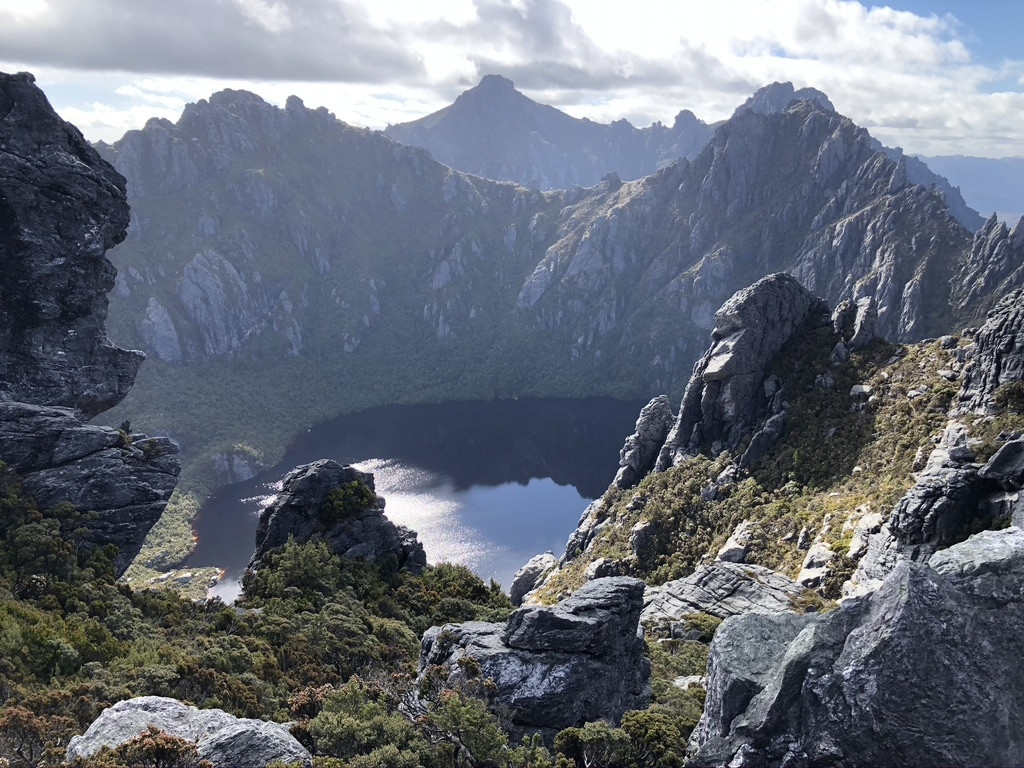
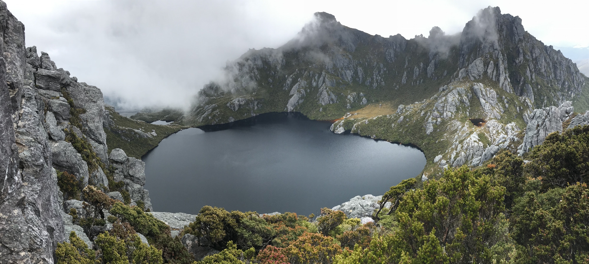
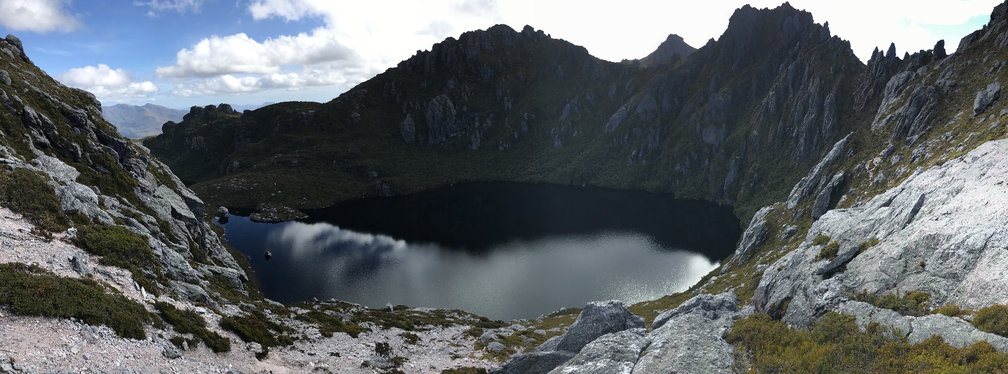
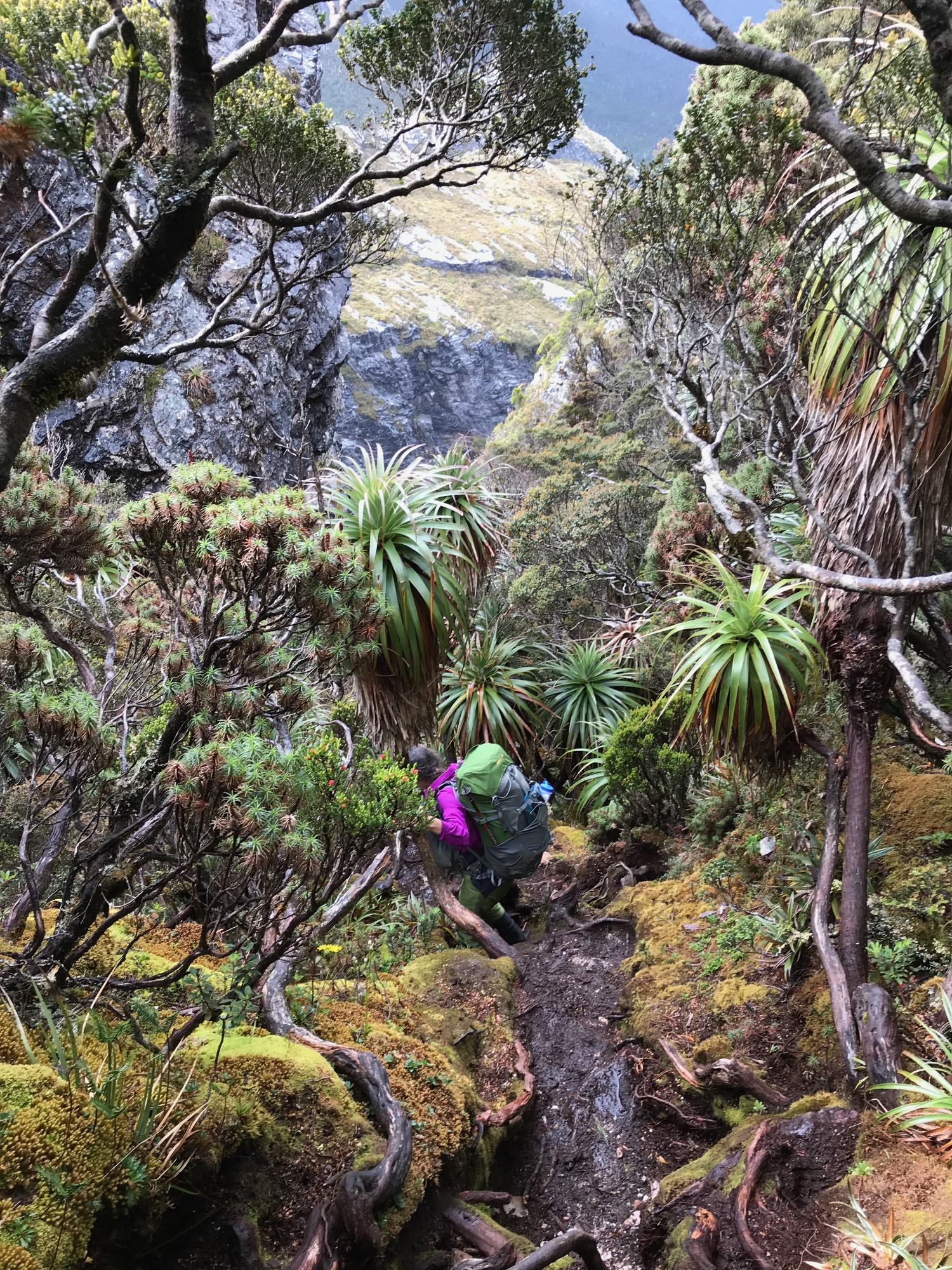
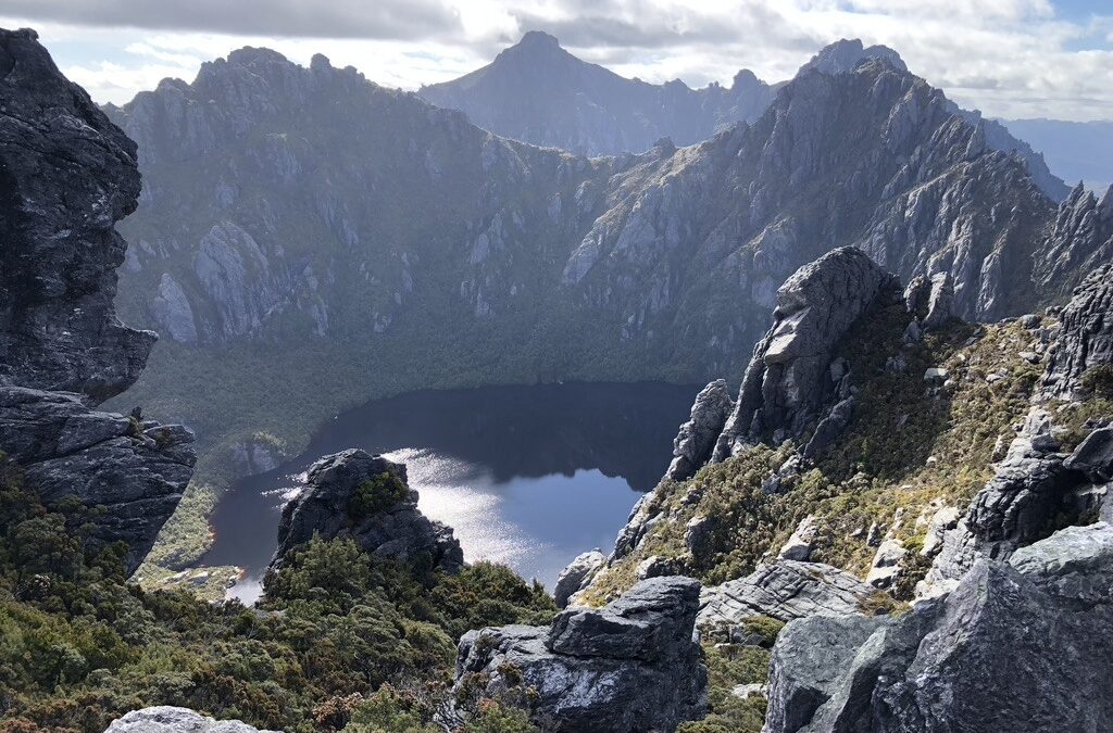
We eventually started to descend towards Lake Oberon, one of the iconic views of the Western Arthurs but destined to remain unseen by us on this trip. This is the first of the famous cirques, deep basins carved into the mountain by a glacier, a lake at the bottom dammed by the moraine of the retreating glacier, and walled in by a couple of hundred meters of steep, scrub-covered slopes below a crown of jagged peaks slashing at the sky.
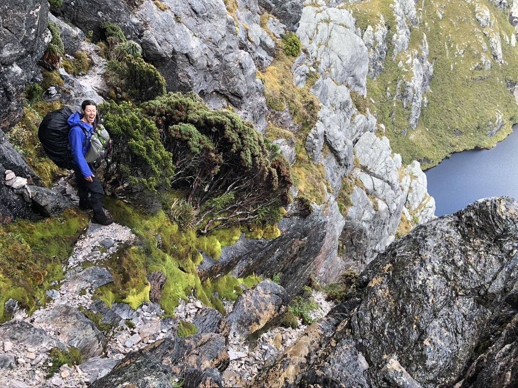
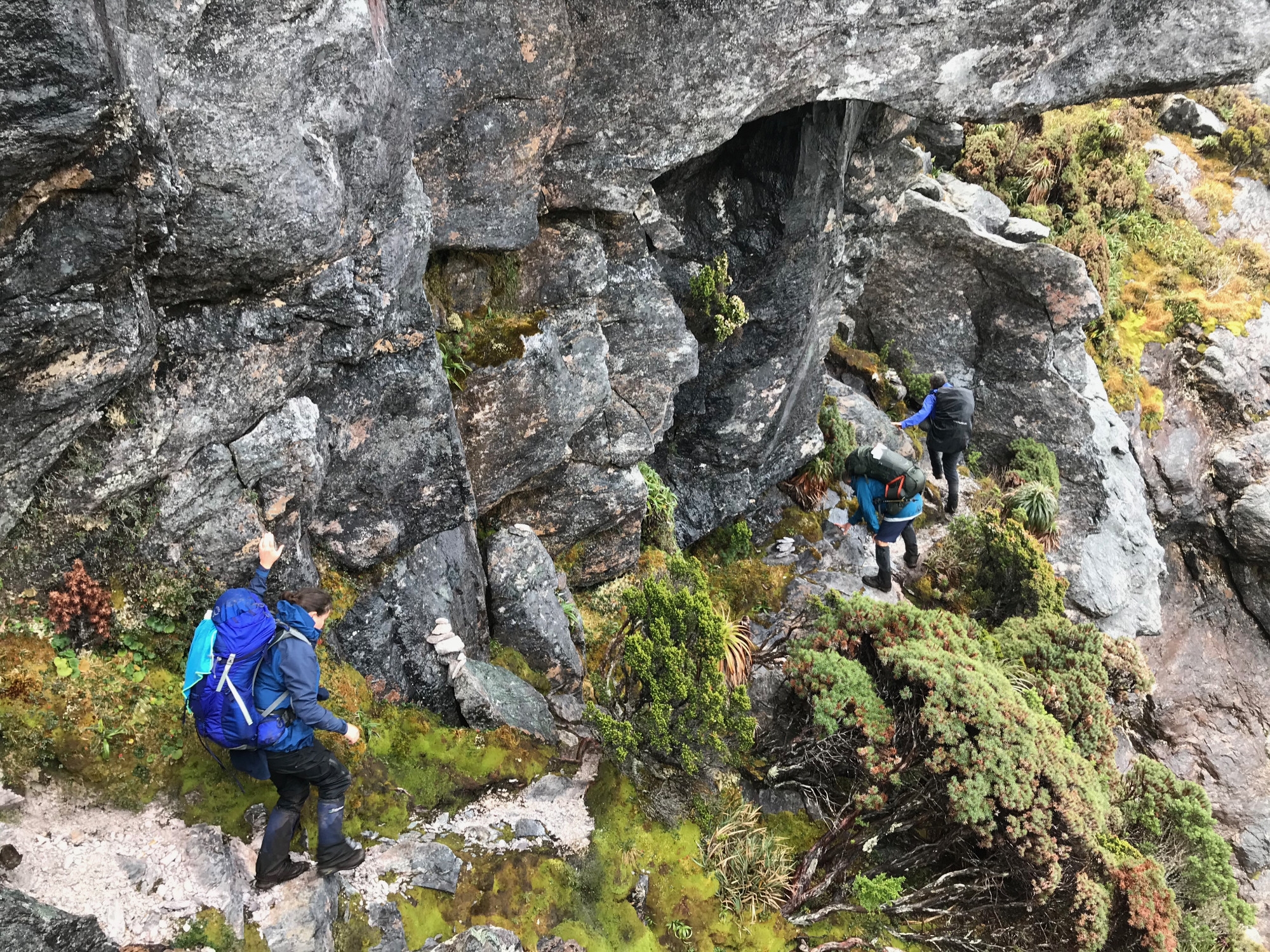
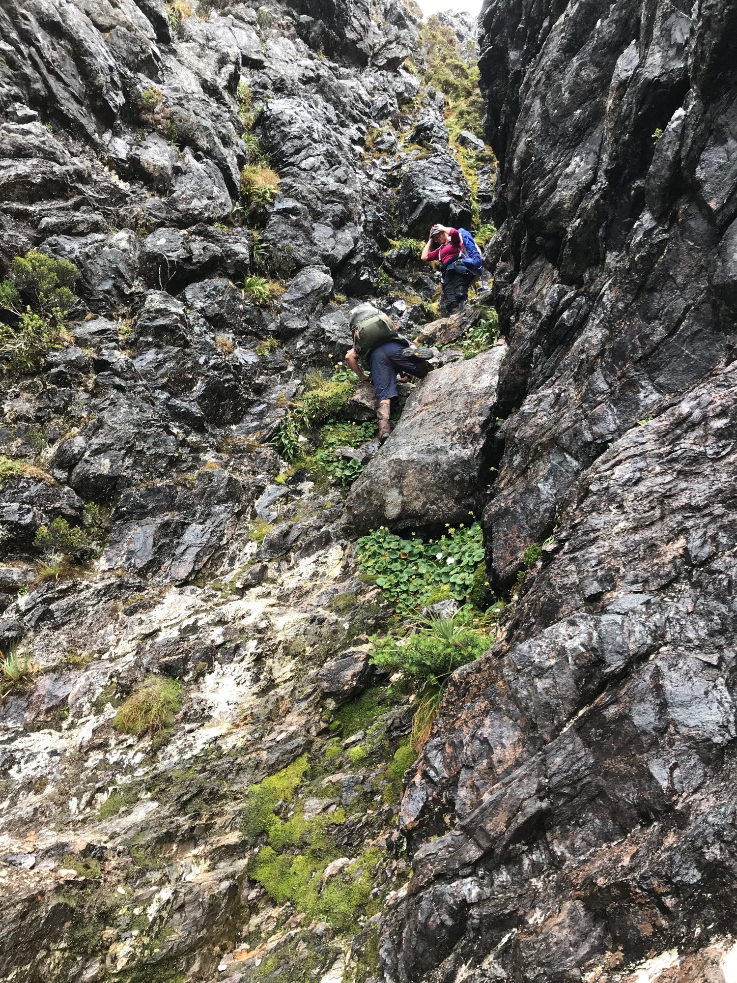
But all this was hidden in the fog as we descended a steep quartzite gully hard up against one of the peaks. This was the first point where we had to turn around and downclimb, the rock was streaming with water and we were all cold and tired. It was a relief to get into the scrub and head diagonally across the slope to the lakeside campsites.
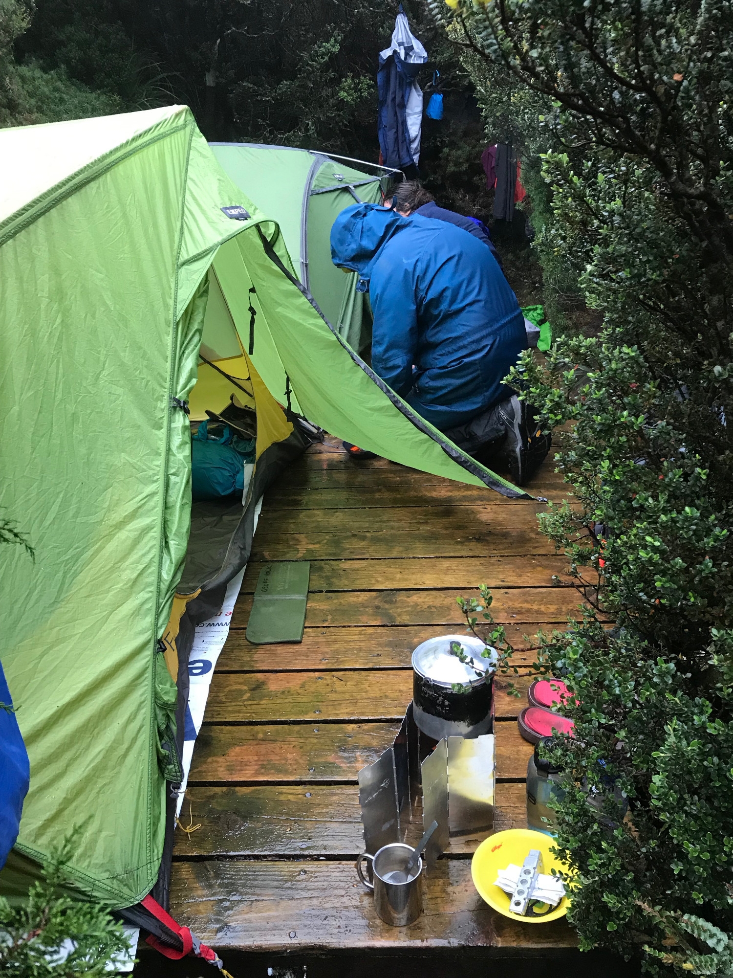
The tent sites are again cut into the scrub to provide some shelter from storms – four wooden platforms reached by little tracks from a main track that by this point was not beside the creek but simply part of the creek. The two centre platforms were occupied by a couple in an ultra-light cuben fibre tent, and by the Illawarans who passed us earlier. We did not fancy a 100m wade to see our companions, so with some effort we succeeded in getting two tents on one platform, each with one accessible door.
Kirstie was the coldest, so as soon as the tents were up she changed into her reserve thermals, got in her sleeping bag and became a disembodied voice. Following her instructions I prepared the excellent coconut cream curry which she had planned, but by the time this was complete I was quite cold. Warm food helped, and immediately afterwards, at Geoff’s suggestion, I climbed into my sleeping bags and waited for my body heat to drive the water out of my thermals and through the down. In the prevailing conditions this was very effective – it would not always be advisable – and in the morning I had dry merinos and a reasonably dry sleeping bag, with the last of the moisture able to be wiped off the outside with my towel.
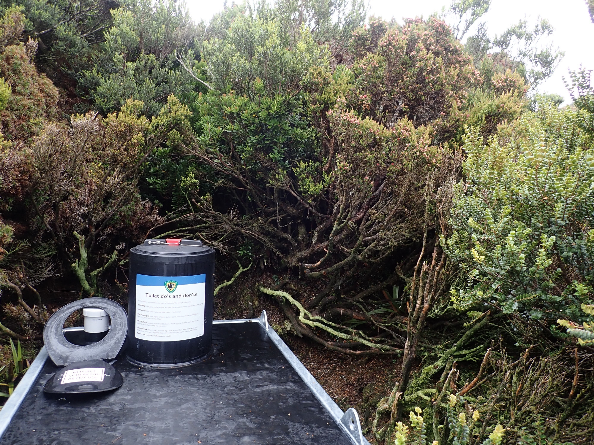
Visiting the toilet platform that night, a seat mounted on a large plastic box and regularly flown out by helicopter, there was a break in the rain and a late-rising full moon. The haloed moon with clouds scudding across its face and the circlet of tortured, black crags all around us were magnificent.
Day 4. Peaks, Saddles and the Hole
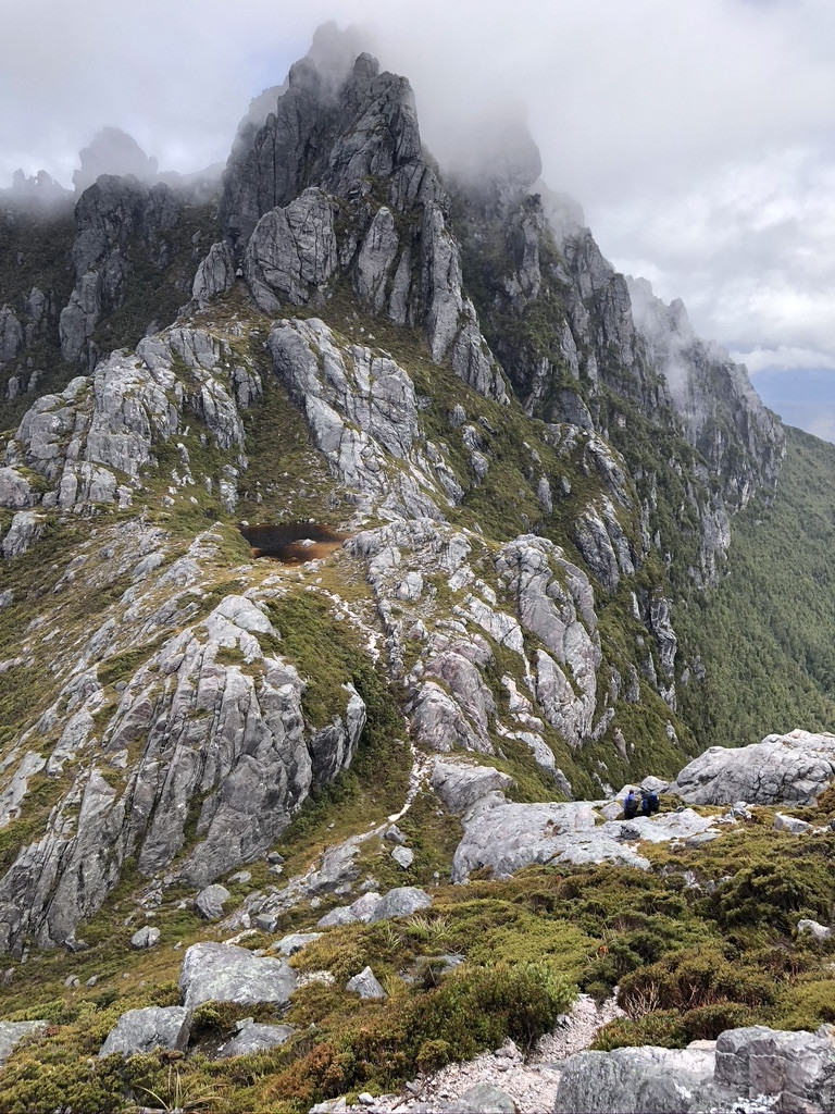
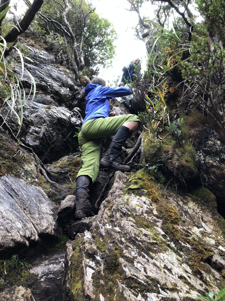
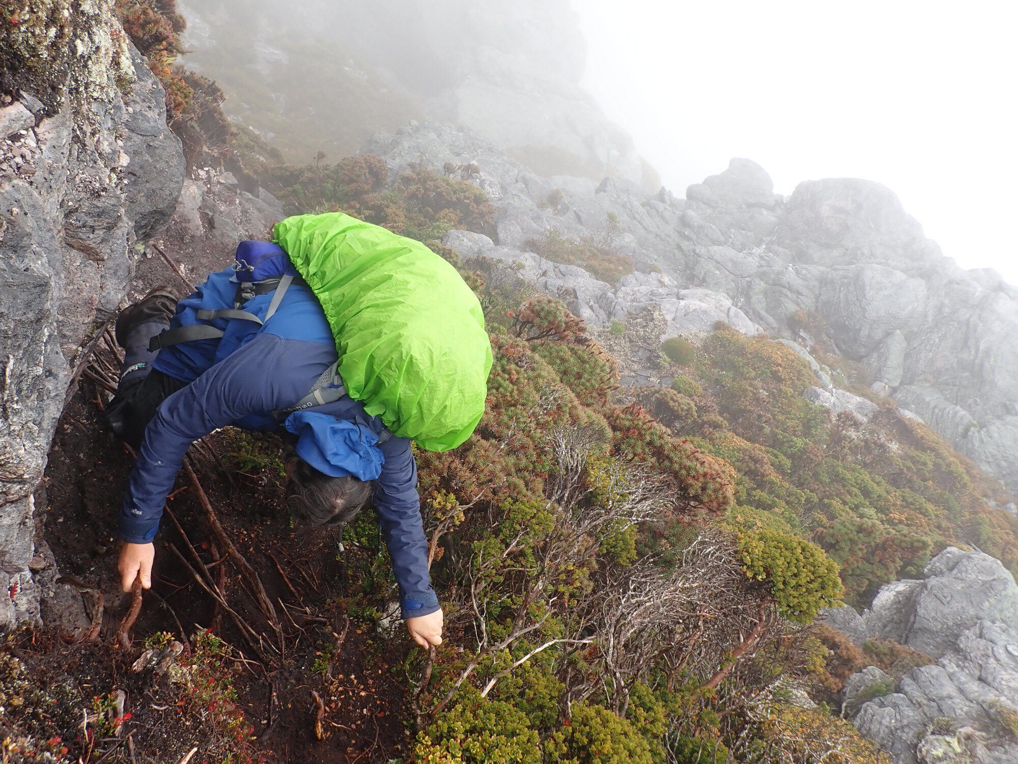
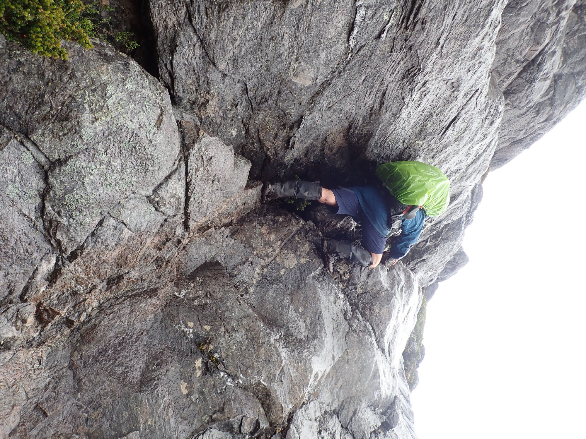
It rained most of the night, although not heavily and without strong winds, and the morning drizzle was uninviting. Chapman advises against undertaking the next section without good weather, so after breakfast we hung around and visited the gorgeous little beach of fine, white quartz sand. Eventually, around 11.00, we decided to set off but to abort after a couple of hours if weather conditions did not improve. With sunset at 8.45 we had plenty of time to complete the 4.3Km to High Moor, or so we thought. After climbing 200m back to the ridge we started to ascend Mt Pegasus. “The route”, writes Chapman, “now penetrates the roughest and most exciting part of the range”, and he speaks truly. An early obstacle where a short climb up a rockface is needed to regain the track had my heart in my mouth – easy scrambling, but less so on wet rock with a big pack, and the key to keeping moving is to pack-haul only when absolutely necessary. Near the summit we passed through the famous ‘hole’ where packs must be passed up through a vertical section of ‘track’, but this proved straightforward.
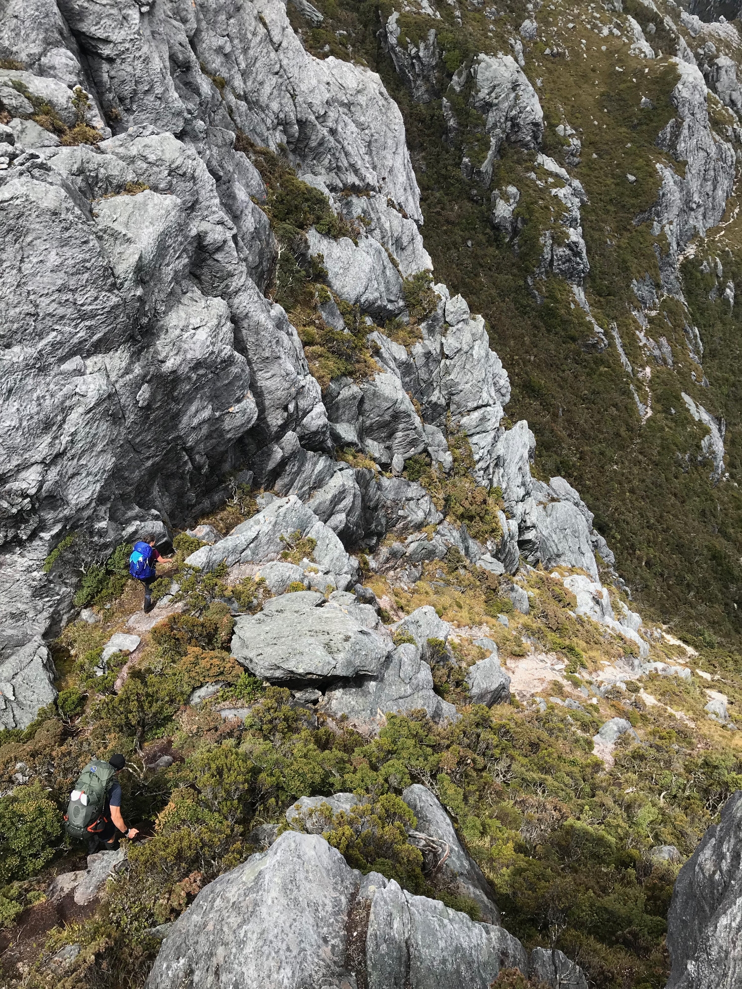
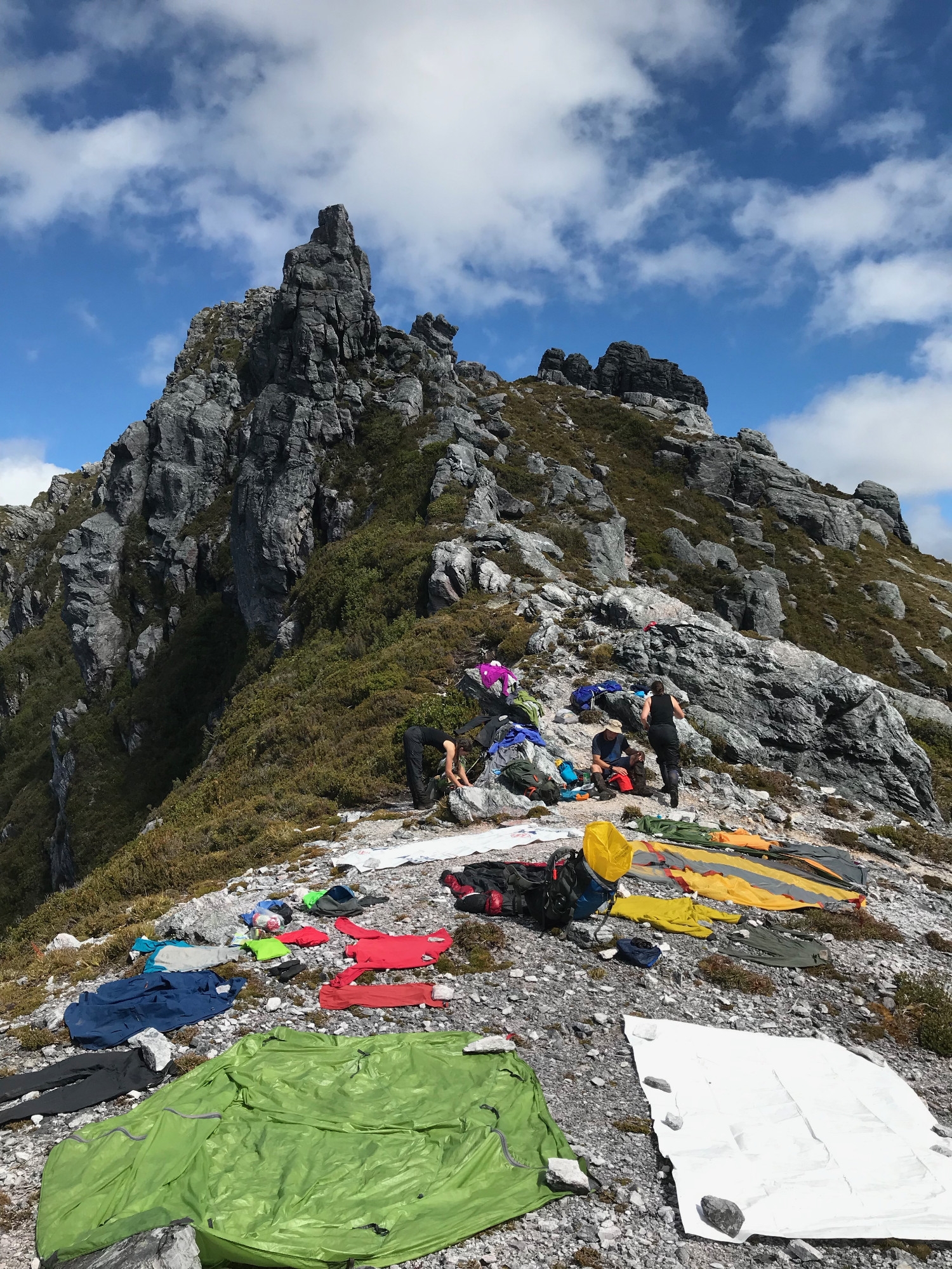
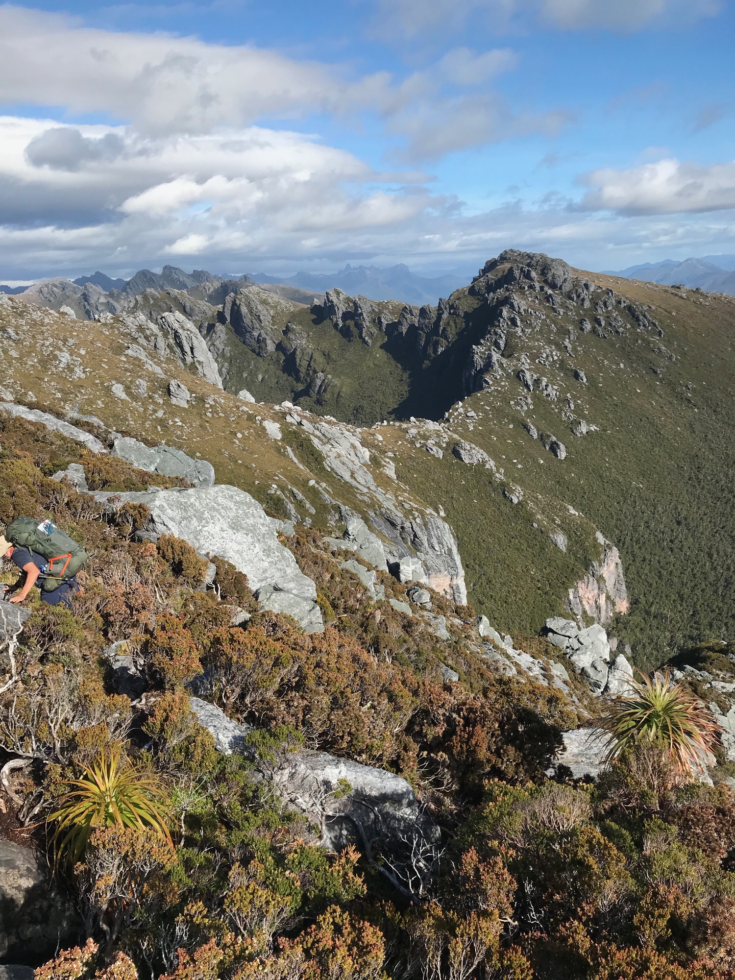
We decided not to summit Pegasus, as there would be no views in the fog. Instead we descended a steep gully and followed the ridge to an open saddle between Pegasus and Capricorn. As everywhere in the Arthurs, following a ridge means descending and ascending to traverse around rock pinnacles, or occasionally climbing over the top, so it is a slow business. Our horizontal rate of progress this day was 500m per hour. In general, our times were about 50% more than the median time indicated by Chapman, which we heard is not unusual. As we descended Pegasus the weather lifted and on reaching the saddle we stopped for a proper lunch, surrounded by our brightly coloured tents, sleeping bags and clothes drying in the sun. This raised our spirits immensely. It’s rare in Australia to walk in bare, rocky mountains where the bright colours of so much outdoor gear seem appropriate. For the most part, Australian bushwalkers prefer muted, natural colours that blend into the bush. But here the bright reds, greens and blues favoured in Europe and North America seemed completely at home.
We followed the ridgeline to the relatively easy ascent of Mt Capricorn and reached the summit just before the Illawarans caught up with us, having started even later. By now there was bright sunshine and the views as we scrambled up onto the rocky spire were extraordinary. To our east the range stretched away, becoming the Eastern Arthurs and ending at Federation Peak, “Australia’s only real mountain” as Edmund Hillary described it. Behind us, to the west, we had our first proper view of the cirques of Lake Oberon and Lake Uranus, two circlets of quartzite pinnacles above green slopes running down to black lakes fringed with gold.
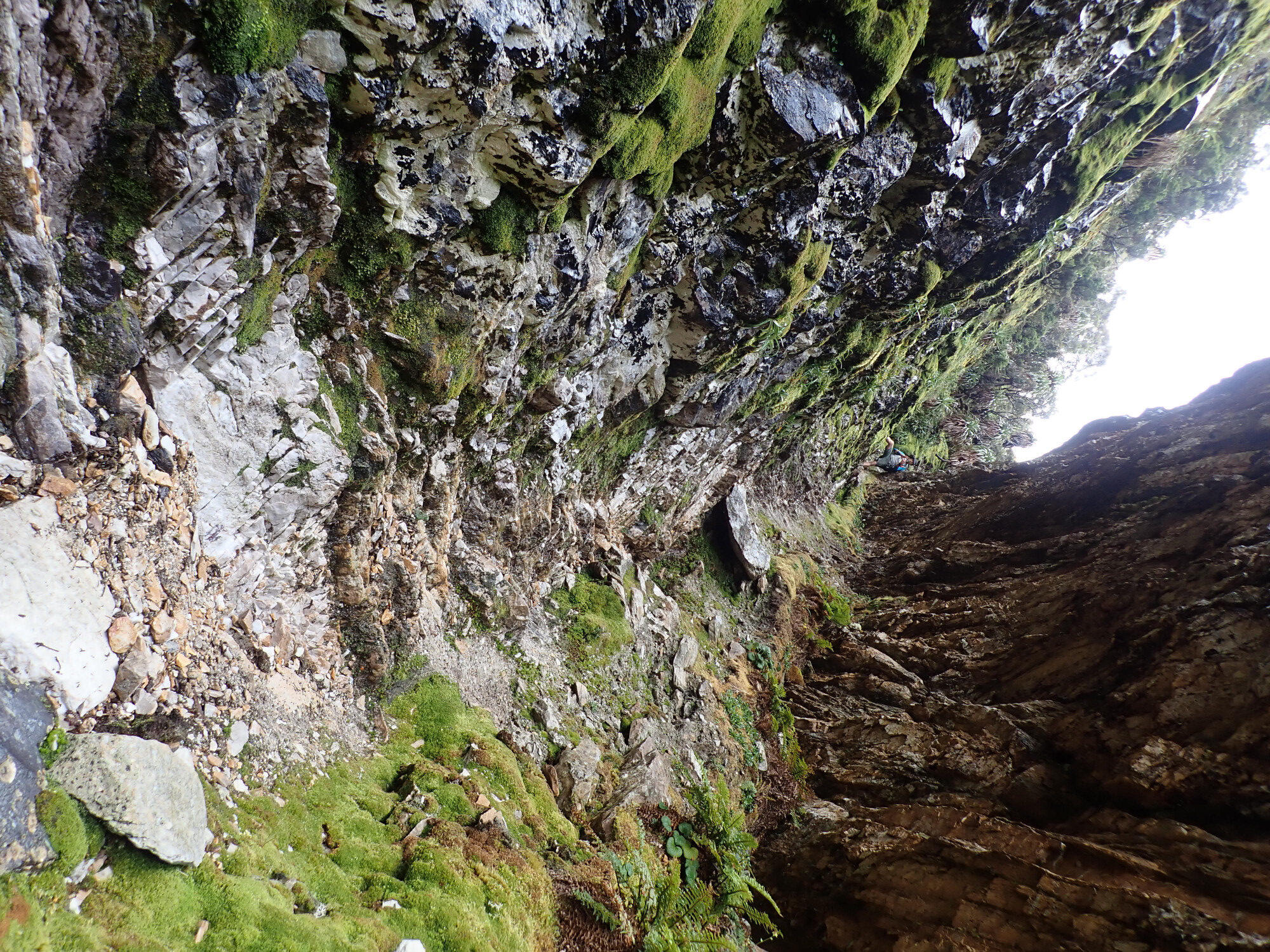
The descent of Capricorn was the most disconcerting part of the trip so far. After some relatively conventional slopes and gullies, and another ‘hole’ to pass packs through, downwards this time, we encountered what Chapman describes as a “very steep descent on tree roots and bushes”. We christened this section ‘the mud ladders of Mt Capricorn’. Looking back later we could see that this final slope of the mountain is about 20 degrees off the vertical. It is thickly covered in scoparia scrub. The creators of the route must have forced their way down through the scrub, less concerned about falling than about the effort of pushing downwards. But with the passage of many walkers the track has become the narrow canyon of mud familiar to all walkers in SW Tasmania, but in this case on a near vertical slope. The track is thus a series of ‘ladders’ with footholds kicked into the mud and roots and handholds of roots and branches – broken stumps worn smooth by many hands. At the foot of each ladder the walker is separated from the void by ledges of mud and roots perhaps half a metre wide, traversing to the next ‘ladder’. Occasionally the rock protrudes, but as the resulting holds are usually sloping and covered in ooze that’s no comfort. The mud ladders went on for what seemed an age, perhaps as much as 100 vertical metres, until we emerged, relieved, on the ridge.
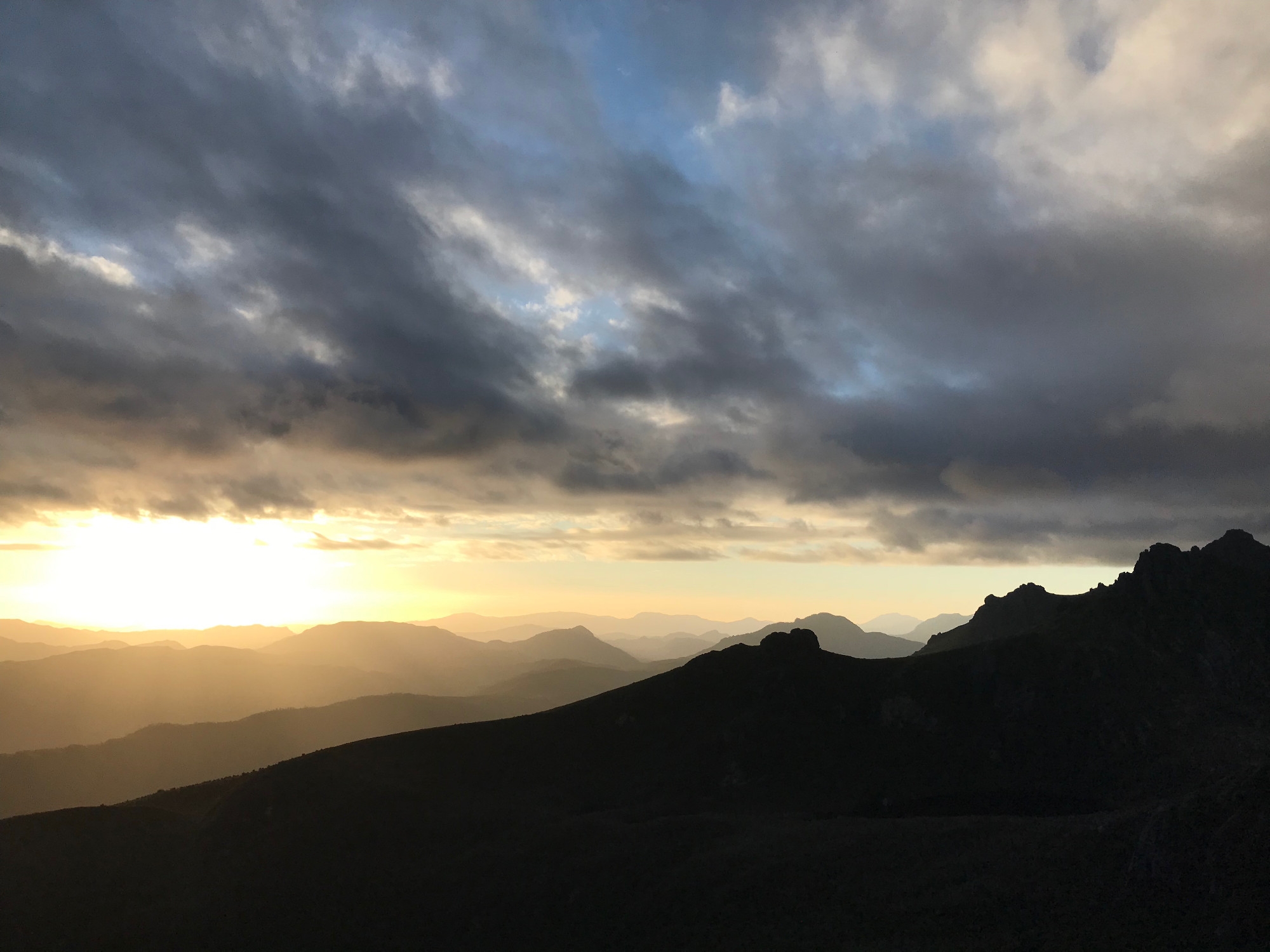
“Campsite soon”, we thought, happily. But more ridge walking awaited us, and even as we began to angle across to the saddle above High Moor progress was slow. Under the scrub is a boulder field, or as the French more accurately call it, un chaos de blocs. Simultaneously scrambling over boulders and through scrub we eventually emerged onto the open moorland, where boardwalks have been installed to protect delicate plants from trampling feet. The sun was starting to set in the west and we began the most beautiful evening of our trip.
Range after range of hills were outlined against the setting sun, looking like two-dimensional stage-scenery. Between them sea inlets like Bathurst Harbour glinted like polished steel, and finally, in the distance, we could see the continuous horizon of the Southern Ocean. Best of all, we knew there was nothing between us and Antarctica more ‘developed’ than the thin strip of timber on which we were walking.
It had taken us nine hours to cover the 4.3km from Lake Oberon, and we reached camp just in time for us to set up our tents and cook before dark. The two parties from last night were already there, Cuben Couple and the Illawarra Three, but at this outstanding campsite there was plenty room for us all. Perhaps because it is the most exposed camp on the traverse High Moor has been recently and very well renovated. A single, expanse of wooden camping platforms easily accommodated five tents, with room to come and go. Because the platforms are on several levels we could sit comfortably on one level with stoves, etc at our feet on the next. Boardwalks connect the campsite to the water source and the distant toilet.
We ate a fine meal of miso soup with black fungus and tofu knots, followed by a small, celebratory whisky. Our view northeast over the Arthur Plains was framed by the peaks on either side of the moor and decorated by a wild pinnacle of rock erupting from the moorland in front of us.
Day 5. The Beggary Bumps
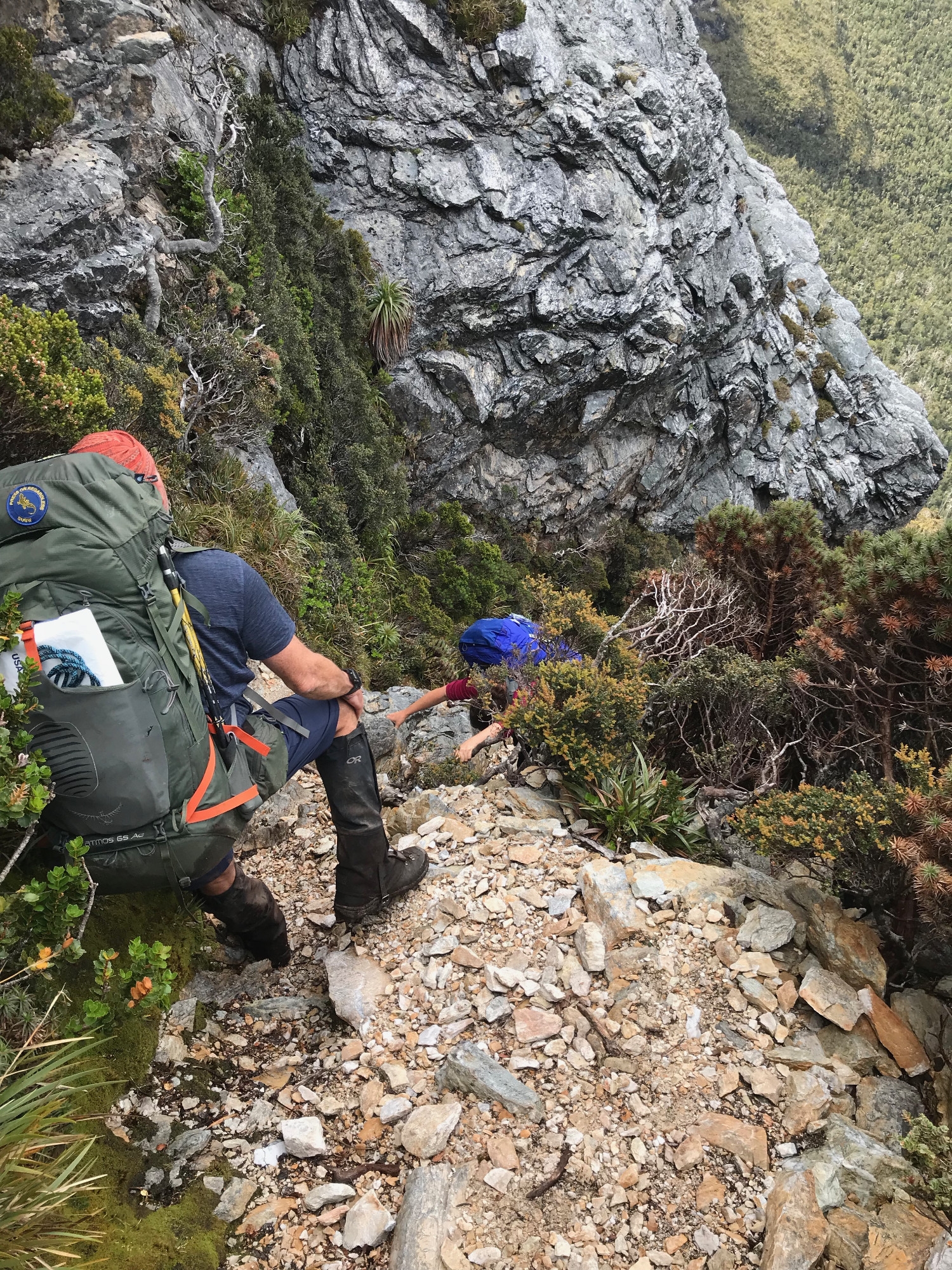
This part of the ridge is named because, as Chapman writes, “There are many awkward descents and climbs along this section”. The rock pinnacles, or bumps, are negotiated by descending narrow quartzite gullies, traversing through the scrub beneath each pinnacle, and then reascending to the ridge. It’s a slow business. One of the gullies is highlighted by Chapman as The Tilted Chasm, but we found at least two of the other gullies equally hard. Climbing down each gully they appeared to end in a precipice, but in each case smiles spread across our faces as we looked over the edge and saw a relatively easy climbdown. The first walkers must have descended many other, less friendly gullies to find these ones!
The third bump is the Dragon, named for the pattern of convoluted rock strata in the cliff face as you approach it. Quartzite is ancient sandstone transformed by heat and pressure and at places like this you can clearly see the immense forces that have acted upon it. Passing the Dragon we were relieved to find that another famous obstacle, Lovers Leap, has been circumvented by yet another descent of a gully – this time steep enough that we used our rope to lower packs for the first time – and an ascent back to the ridge.
More bumps followed and after so many hours clambering up and down to make tiny amounts of forward progress we properly understood the name Beggary Bumps. Mist descended, and when we stood between the twin peaks that give Mt Taurus its name visibility was minimal. Keen to reach Haven Lake before rain set in we pressed on, emerging below the clouds to get our first view of the lake. The descent of Taurus was deceptively long and steep, repeatedly promising access to the moorland before revealing another downclimb. At the very end of the descent the track is a cleft in the rocks, easy enough to chimney down, but not with packs, leading us to get the rope out a second time.
Eight hours after leaving High Moor we walked across the moraine of Haven Lake, where some old, exposed campsites have been closed off, to another cluster of wooden platforms cut into the scrub. This is an older build and the small platforms were only practical for one tent. Cuben couple were already there, and the Illawarra three would be arriving soon, so we occupied two adjacent platforms leaving the highest and driest for them, where a tent off the platform would not actually be sitting in water. Soon, however, we were amazed to see a solo walker arrive who had not been at High Moor that morning. An American environmental scientist exploring Tasmania for the summer, this young woman had walked several other tracks about which National Parks had posted dire warnings. Since there were no adjectives left to properly describe the Arthurs, she had assumed that two 4Km sections would combine to make one easy day’s walk. Here she was twelve and a half hours later with an expression on her face I had not seen before. We were suitably impressed, especially when she was up and away at 6.00 the next morning having pitched her tent on the only remaining square of dry ground.
The sun came out briefly and we ate dinner on rocks by the edge of the lake. The view was beautiful, but the bitter wind drove us back to our tents just before sunset. This was to be our coldest night on the trip, a few degrees above zero.
Day 6. Down, Down, Deeper and Down
Our plan, as we climbed to the ridge above Haven Lake, was to make a side trip to Mt Aldebaran before returning to the main track and descending to camp at Lake Sirona where Chapman says “the main difficulties end”. When we reached the ridge we were in freezing fog and an out-and-back trip to see some slightly higher fog seemed futile, so we continued to Lake Sirona. The walking was very similar to the previous day, but in heavy fog. The lake emerged from the fog when we were just a few metres away and as I had mistakenly come to believe that this was Lake Sirena, I remarked that the rock in the middle was where the mermaid sat.
There are no facilities at Lake Sirona and the campsites are rocky and exposed, making it unappealing in the cold fog, so we abandoned the idea of camping here and attempting Aldebaran next day. On we walked. The track comes very close to the summit of Mt Scorpio and the clouds lifted just as we reached the next saddle. Dropping packs we briefly backtracked and scrambled up to the summit to be rewarded with a final set of magnificent view back along the range and across the rest of Southwest National Park to the ocean. After lingering here for some time we started down the long, gentle, winding ridge of Kappa Moraine.
We considered camping at Lake Vesta, in the saddle between Scorpio and Sculptor, as we had plenty of time and were reluctant to leave the mountains. When we reached the turning, however, we found that this was clearly signposted as part of the area closed since the big fires of 2018. This left us no alternative but to carry on down Kappa Moraine, and as we approached the plains we felt satisfied with our decision. We were leaving on a high. There was no need to linger.
The track across the plains to Seven Mile Creek could have been as muddy at the Port Davey track, but instead it was the driest track I have encountered in the southwest. Partly this is because it follows a long tail of moraine, elevated slightly above the plain. But the main reason is less positive. As we descended the moraine we encountered the edge of the huge 2018 fire. The peaty soil on which the Button Grass grows has a very high content of organic matter, and the soil itself it seemed to have burnt, transforming it from its usual sponge to a hard crust. Under normal circumstances this soil retains so much water that you can detour below a swamp to find firmer ground, or splash through a slough of liquid mud on a steep slope, the water showing no regard for the law of gravity.
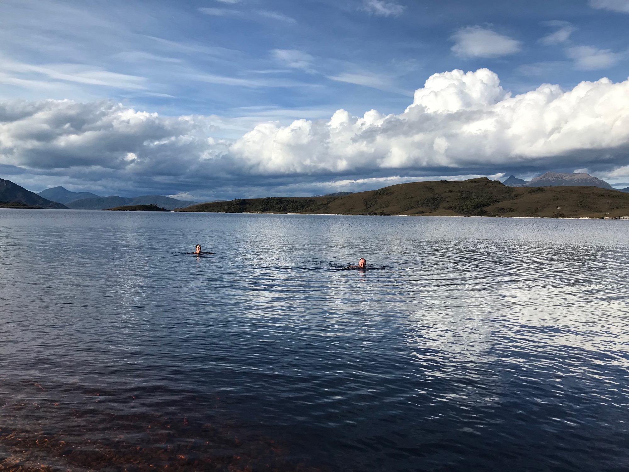
We had the Seven Mile Creek campsite to ourselves, the other parties having taken the shortcut track across the plains – muddy and hard to follow we later heard. Two creeks meet here and flow on towards the Huon River, and with so much fast-running water we could not resist a swim, however cold. We ate dinner feeling cleaner than for some days.
Day 7. Meandering Homewards
Next morning we had no reason to leave camp early. Kristie led a brief yoga class to work out the stiffness from the past few days and eventually we set off to walk the 11km to Junction Creek. Easy walking similar to the previous day took us to Two Mile Creek, five miles from where we started. The sun was out and the unaccustomed temperatures down on the plains seemed far hotter to us than they would have seemed a few days earlier. The whole range was laid out like a panorama photograph as we walked parallel to our route along the peaks. Conversation centered on identifying each features and recalling what they were like close up. It was a rewarding way to end the trip, and we were very pleased to have this wind down time. We stopped for lunch at Two Mile Creek, on a fairy meadow of moss in the welcome shade of the big trees along the watercourse. Arriving at Junction Creek camp in the afternoon we had a swim and siesta before a relaxed dinner. The camp was quiet, but we passed on Geoff’s hard copy of Chapman’s notes to a solo walker heading in who did not have them.
Day 8. The End of the Affair [5]
After a leisurely breakfast we walked the four hours back to the road at Scotts Peak Dam. Nearing the end we found ourselves back on the well-made track and able to enjoy the stunning views of Mt Anne and its range in the bright sunlight. We recovered our food cache and found the car-based campsite, admiring such luxuries as walled toilets and a wet-weather shelter. After establishing ourselves at the campsite we set out to explore the area and discovered a boat ramp and swimming area behind the dam on Lake Pedder. The water seemed tropical after the creeks on the Arthur Plains and we floated in it long and luxuriously. In the evening we returned for another swim and then walked out along the dam wall to dine with panoramic views of the range and the sun going down in the west.
[1] With apologies to Lord Byron
[2] South West Tasmania, by John Chapman. 6th Edition 2017.
[3] With apologies to CEW Bean
[4] With apologies to W. Shakespeare
[5] With apologies to Graham Greene