Trip Report: Exploring the lower Grose River and Linden Ridge
Party: Tim (T2) Vollmer, Mary Merlo and Grant Billen
Date: Saturday 5 to Sunday 6 May, 2012
Full trip report online with photos: http://fatcanyoners.org/2012/05/05/grose-river-linden-ridge/
If you mention the Grose River to most people they think of towering cliffs surrounding a spectacular gorge, with majestic stands of blue gums and plunging waterfalls.
That idea isn’t surprising — this stunning upper gorge is what gave birth to the conservation movement in Australia and lead to the eventual formation of the Blue Mountains National Park after all — but how many people stop and ponder what is in the other two thirds of this river’s course.
I’m as guilty as anyone of spending all my time in the upper mountains, where numerous canyons — including some particularly spectacular slots — have carved through the rocky rim of the Grose, and the expansive cliff-top views seem to go on forever.
So when Mary said she wanted to go for a “good sweat, a few kilometres in the legs and awesome campsite sort-of-walk” I thought this might finally be my chance to explore a section of the lesser-visited lower Grose.
While the area is much lower down the sandstone plateau that makes up the mountains, and lacks the iconic towering cliffs, it is still a wild labyrinth of winding ridges and deep creeks that cut through a wilderness without a lot of distinctive features to guide you.
In fact, the first European to try and explore this region, the botanist George Caley, named it the “Devil’s Wilderness” after his failed attempt in 1804 to cross the Blue Mountains. (Interestingly he did make Mt Banks, and look into the upper gorge, which he declared would “forever remain an unsurmountable barrier”.) Our trip planned to be a substantially easier journey than his three week epic!
Three of us met up at a reasonably civilised hour on the Saturday morning, quickly grabbing our gear and hitting the fire trail out Faulconbridge Ridge. It was easy going, and we made great time, chatting away as we walked on the easy path through open forest.
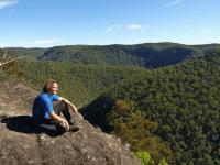
Before we knew it we hit the lookout at the end, pausing for some photo-pfaffing of the spectacular gorge below. From here we could not only see the entire lower river as it carved its way through the last of the mountains to the Sydney basin, but we could also see our destination for the night, Wentworth Cave.
We returned to the fire trail, back-tracking about a kilometre to where an easy old track drops down to the river.
Once at the river we paused for a quick morning tea break, admiring the impressive swimming hole at the bend where the track arrives. We managed to resist the call of the water, probably because it was still a little chilly, and we set off along the river bank.
We followed a track of sorts, finding some occasional signs of stone works and other remnants of the bridle trail known as the Engineers Track that was built in the 1850′s as part of a plan to put a railway through the valley, but it came and went and had us regularly pushing through fairly thick scrub.
Given how slow the going was, I spent plenty of time shaking my head and wondering how the freaks that have run this river in a day ever managed to do it. It was hard enough to get into a decent rhythm walking, but the thought of racing along the uneven, scrubby, rocky, slippery, mossy, slimy, rotten, loose-rock slopes just blew me away.
Eventually we made it to the next sharp bend in the river, where the satellite images had convinced me we might find a good lunch spot next to a huge pool. While there was an enormous swimming hole, it was almost too big, and the sandy beach that I’d seen had almost been completely washed away by the recent heavy rains.
It didn’t take long to decide we should push on, so back into the scrubby slopes we went. Again there were patches of old track, as well as more open rocky slabs, but it was still fairly slow going.
Finally, about 200 metres from Linden Creek (and almost directly below the lookout we’d been at hours earlier) we found the perfect lunch spot.
This place was stunning. A huge, flat boulder in the middle of the river, attached to the shore with a sandy beach. Sun streaming down, deep water for a swim, and all just a few kilometres from our final destination. Perfect.
Eventually the sun started dipping lower, and we could see the shadows rushing towards us, so we decided it was time to dry off, pack up and get walking again.
It was just a matter of minutes before we reached Linden Creek. We crossed over, discovering a wonderful protected camp site under the trees. Above it, a few metres up the cliffs, was an impressive camp cave that obviously gets a fair bit of use from local fishermen if the rod, shoes, clothes line and other accoutrements were anything to go by.
The next few kilometres to Wentworth Creek were actually much better. I’m not sure if we’d just got the hang of moving through this particular terrain, but the old track seemed much better, and we seemed to stick to it for the bulk of the distance.
Eventually we got to Wentworth Creek, which is an impressive sight by this point, having drained a huge area of the mountains. After a few minutes of clamouring amongst the water gums we eventually found a reasonable spot to cross, with the flow just too high for several areas to be done safely.
Once over it was a quick scramble across the slippery rocks to the base of the cliffs where we found Wentworth Cave. This camp site was perfect for us, providing plenty of shelter, but it was far less impressive than I imagined given it was used by the band of 50 or so men who had built the original track through here all those years ago. In fact we’d passed several other caves that would provide a small group with much better protection in bad weather.
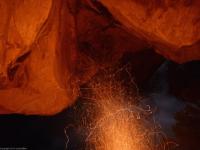
After setting up camp we went for a swim in the icy waters of Wentworth Creek, washing off the day’s grime, before lighting our camp fire and settling in for the night.
The evening was one of those magical, indescribable nights that you always hope for when bushwalking, but don’t often get. The sky remained almost entirely cloudless, the rising moon was spectacularly bright given it was full and about as close to the earth as it ever gets, we had heaps of wood and there was no wind about.
After a pleasant dinner and some very welcome wine we headed back to the river bank, squeezing yet another quick dip in under the luminous full ‘supermoon‘ (my apologies to any astronomers who are cringing at that phrase), before the chill air forced us back to the fire.
By the time we hit the sack, some time after midnight, the moon was directly overhead and was illuminating everything. Luckily Mary and I had chosen spots further under the overhang, as Grant found it very hard to get to sleep in the bright glow.
Come morning we were woken by the crackling of the breakfast fire, which Grant had generously got going. Whether it was the promise of a warm fire, or just the guilt that comes from being the last one sleeping, we finally dragged ourselves out of our warm sleeping bags and headed over.
I regretted my cup of tea and muesli bar breakfast when the others got a bit gourmet, with Mary pulling out the jaffle iron while Grant brought out a four-course feast including bacon, scrambled eggs, crumpets and pretty much every other luxury item you could imagine.
Eventually we packed up and started our climb up Linden Ridge. The lower section was nice and easy, with some fun little scrambles quickly giving us some elevation. Things briefly flattened out as we crossed a narrow rocky causeway before we started approaching the main cliff-line.
Considering how far down the mountains we were, these cliffs were pretty impressive, and continued to our right for a long distance. We went left, given the topo map seemed to promise they’d ease on this side.
We had a look at a couple dicey scrambles that would get us to the top, including one where a large hold broke, before deciding just to sidle for a while and look for an easier pass.
This was nearly our downfall when we heard an almighty crash and a shout come from behind us. We turned around to see Mary sprawled in the undergrowth, in obvious pain, after a huge rock that would have weighed a good 200kgs rolled as she stood on it.
Mary was in serious pain, but thankfully she’d fallen on the rock, rather than the other way around, and quickly worked out that while there was some serious scratching and bruising, nothing was broken.
We pushed on, eventually finding an easy route up that took us below a long line of overhangs, which we walked under back towards the nose. A final easy scramble, and a push through some scrub, and we were on the rocky outcrop at the end of Linden ridge.
Below us curved not only the Grose River, but Wentworth Creek, which cuts a surprisingly impressive gorge between the ridges. We could see all the way over the rolling ridges towards some of the few recognisable peaks, such as Mt Tomah and Mt Hay.
We paused here to give Mary’s leg some recovery time, and because we figured this was probably the best view we’d get all walk.
Eventually we pushed on to the main part of Linden Ridge, not really knowing what to expect. What we discovered was really amazing. Unlike Faulconbridge Ridge the day before, this one wasn’t straight, flat and openly forested, it was twisty and windy and scrubby in places, with plenty of little ups and downs over rocky protuberances.
The map and compass really came in handy along here, where the ridge would make a sharp turn in the middle of a scrubby saddle, or we’d be forced off the ridge-top by patches of thick scrub. Our walking became quite slow, making time our new enemy.
As we went on we climbed impressive rock slabs, with expansive panoramic views. There were rocky causeways, and thin rock bands along the edge of the ridge, with the geology being our guide to the easiest route.
We even found some pools of water on the tops, with large tadpoles in one suggesting they last a long time after rain!
On the map an old fire trail is marked, running a fair way out the ridge, and we were looking for this to make up time, but when we hit the hill where it supposedly ended there was nothing.
We pushed along, doing a few zigzags to try and spot it, but despite continuing for hundreds of metres there was still no sign.
Eventually Grant found what seemed to be little more than an animal pad, but it made the going a little easier. While it came and went, it seemed to be getting slightly better, and some occasional remnants of embankments convinced us this must be the old fire trail, almost completely reclaimed by nature.
It was lunch time, but I didn’t want to stop until we were definitely on the track, as I had no desire to do much night walking!
Slowly we became more confident that this was the track — although in places it was like the Kanangra scrub, where you only know you’re on a ‘track’ because it feels different underfoot — so we decided to stop on a sun-drenched rocky slab for our late lunch.
Mary’s leg was giving her a lot of trouble, with the constant pushing through scrub scratching and re-scratching the wound. She tried to bandage it up, but the scrub made short work of the bandage!
Thankfully over the next few kilometres the track started to improve. While there was some erosion in some steep areas, it was amazing to think that a track bulldozed through the wilderness was being so completely reclaimed by the bush. A couple years without anyone walking through and it could disappear completely.
At one point the track circled around an impressive hill — basically a slab of sandstone with cliffs on all sides — which looked like it was well worth exploring on a future visit.
Eventually we hit a maintained fire trail, following it east, then started racing down the steep slope into Linden Creek.
Towards the bottom we were slowed down by a small cliff, then the thick bracken ferns, but we were eventually across and pushed up the other side.
A couple nice little scrambles and we hit a fire trail, right on twilight.
As we walked along the ridgetop we suddenly spotted a bright white light, which looked like a spotlight, but after some puzzled looks we realised it was just the enormous full moon again. Even while low on the horizon it was extraordinarily bright and meant there was no need for head torches.
It was about 6pm when we finally made it back to the cars, and we were all very relieved after what had been a fairly tough day of walking. It didn’t take long to set off and we were soon at the Lapstone Hotel for a couple well deserved beers and a good feed.
We all agreed the area was better than we expected. Linden Ridge had been much more wild and interesting than predicted. Wentworth Creek looked well worth exploring. And the lower Grose proved that you don’t need iconic towering cliffs to make for an incredible spot for bushwalking.
Tim Vollmer
Mob: 0404 273 313
Email: tim.vollmer at gmail.com
Web: www.fatcanyoners.org/