Trip Report – Mittagong to Katoomba 3-9 July 2011
Walkers – Sarah Truscott, Saul Richardson, Dave Noble
Online report and photos –
http://www.david-noble.net/blog/?p=198
More photos –
http://www.david-noble.net/bushwalking/MTKJul2011/MittangongToKatoomba.html
Myself and Saul caught a train to Mittagong, where we met Sarah and her partner James who had driven up from Canberra. The plan was to drive out to the start of the walk near Hilltop, then for James, who had only come for the first day to drive the car back to Canberra.
At Mittagong we enjoyed an expensive egg and bacon roll and coffee, then set out for Hilltop. Here are brief notes on each day –
Day 1
Down Starlights Trail to McArthurs Flat on the Nattai for lunch. We then farewelled James and set off down the river. Going was quite reasonable on the Sloss track. We camped not too far before an old farm road on a nice river flat.
Day 2
We continued down the river, joining the farm road, then continued along that to Vineyard Flat at the bottom of Beloon Pass. The route up to the pass was quite well marked and we made good time – arriving at the top for lunch. But our timing was bad – a passing squall made it a wet and windy lunch! The wind was to increase and continue for the remainder of the walk. The descent from the pass was quite easy – although the track is hard to pick out in places, and it did not take us long to reach the road at the bottom. The “allowed” bushwalkers corridor through the Wollondilly is very well marked by signs and the consequences of deviating off it pointed out frequently (an $11,000 reduction in your bank balance). The ford across the Wollondilly River has had a lot of work down on it. Huge boulders have been bulldozed into place on the lower side of the crossing and it is almost possible to jump from boulder to boulder all the way across with shoes on keeping out of the water. However we had to take out shoes off to get to the first boulder – and the water was very cold! Once across, we continued up through the Joorilands and camped on a high knoll.
Day 3
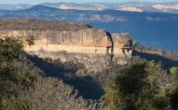
Started with a fairly dull uphill walk to the old ghost town of Yerranderie. Once in the eastern part of the town we noticed a new shelter with water tank which was quite convenient. By this time the wind had picked up a lot and our plan to climb Yerradnerie Peak was cancelled. We instead walked to West Yerranderie and had lunch on a veranda behind the old general store – the only place we could find out of the wind. We then spent an hour os so looking at old mines and mine machinery. Yerranderie is a fascinating place and well worth visiting and exploring. The wind had not abated – so we rugged up and set off walking to Byrnes Gap to spend the night.
Day 4
Original plans to walk next over Axehead Mtn and then along the Bimlow Tablelands or Broken Rock were cancelled. My radio had picked up a report saying the wind warning had changed from “damaging winds” to “destructive winds” and this did not seem conducive to exposed rock scrambling and exposed high camps. So plan B was adopted to walk along part of Scotts Main Range to Mt Feld and then descend to the Kowmung River via Denis Range. This we did with alacrity. It was too cold to stand around. Once in the sheltered river valley it was pleasant to be out of the worst of the wind. However, crossing the river was not too nice! The river level was high and the water temperature was at the lower end of the range. Sarah was feeling a little off colour, probably due to eating some dehydrated mushrooms with her dinner the night before, so we spent a lazy afternoon next to a roaring fire at the bottom of Roots Range. Our original plan B had been to continue down the river and then cross to the Coxs via Veyret’s Horse Track over the Low Gangerangs. None of us were too keen on more river crossings so we adopted plan C – head up to Gingra and then to Kanangra Walls and walk to the Coxs via Cloudmaker.
Day 5
Still very windy weather. We climbed up to Gingra Range via Roots Range, then a fast walk to Kanangra Walls. We had a sheltered lunch in the camp cave at the eastern end of the Kanangra Plateau and then more fast walking out along the Gangerang Range to a high camp on Mt Stormbreaker. We spent a very cold and breezy night on the peak. Snow seemed to be falling on the Thurat Range nearby.
Day 6
We had a cold and windy breakfast, huddled next to the fire, but as soon as we started walking, the wind moderated a lot – and it continued being fairly calm most of the day. We walked to Mt Cloudmaker, then Dex Ck to pick up more water, then to Mt Morilla, where we checked out an aboriginal art site discovered by Col Gibson years earlier. We descended to the Coxs River via Nurla Morella Ridge – which is quite fast and open. Our plan to have lunch next to the river was suspended when we found the valley too shady and icy cold. The river was even colder as we found when we crossed it – and we quickly climbed “The BItch” (Howling Dog) to warm up. Part way up, in the sun, we had a very quick lunch and then continued on the Splendour Rock. Once on top – we found the wind had picked up again – and it was another very cold night.
Day 7
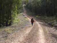
Another sunny but very cold and windy day. We crossed Mt Dingo and Mt Merri-Merrigal and descended to Mobbs Soak to replenish our water supplies. The last bit of the track was a bad bog and it was hard to avoid getting wet feet. We then continued along the horse track through Kennel Flat to Medlow Gap passing a party of panhandlers on the way. Then through the Glens of Guess to Deberts Knob and Narrow Neck, passing more walkers. Narrow Neck was an epicentre for the strong wind – and it encouraged us to make fast progress. We found a sheltered place out of the wind just before the Second Neck to have lunch. Not long after, we ran into Sarah’s mum, who was walking out to meet us, and more importantly give us a lift to Katoomba. Once there, Saul and myself farewelled Sarah and her mum, and headed into Gearins for a few end of trip schooners before catching a train back to town.
Mittagong to Katoomba is a classic Southern Blue Mts walk, even when the conditions are a bit trying – wind wise! Thanks to Sarah and Saul for their good company on the walk.
Dave Noble